Elizabeth elevation
Elizabeth (West Virginia, Wirt County), United States elevation is 196 meters and Elizabeth elevation in feet is 643 ft above sea level [src 1]. Elizabeth is a seat of a second-order administrative division (feature code) with elevation that is 83 meters (272 ft) smaller than average city elevation in United States.
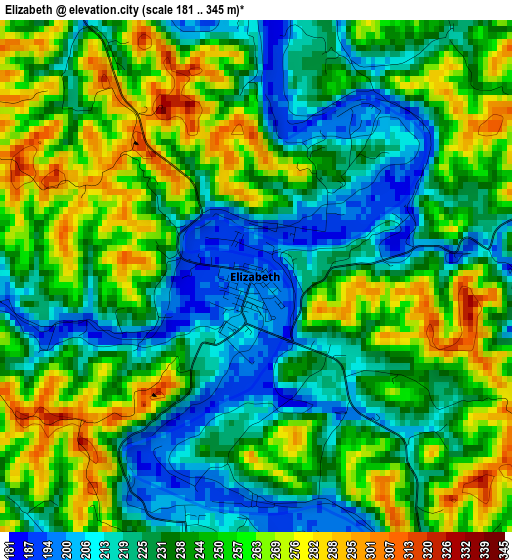
Below is the Elevation map of Elizabeth, which displays elevation range with different colors. Scale of the first map is from 181 to 345 m (594 to 1132 ft) with average elevation of 241.7 meters (=793 ft) [note 1]
These maps also provides idea of topography and contour of this city, they are displayed at different zoom levels. More info about maps, scale and edge coordinates you can find below images.
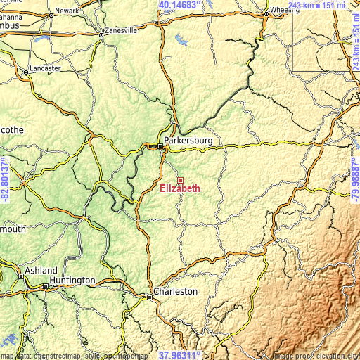
| \ | Map #1 | Topo.Map |
| Scale [m] | 181..345 m | × |
| Scale [ft] | 594..1132 ft | × |
| Average | 241.7 m = 793 ft | × |
| Width | 7.59 km = 4.7 mi | 242.8 km = 150.9 mi |
| Height | 7.59 km = 4.7 mi | 242.8 km = 150.9 mi |
| ↑Max Latitude | 39.097523° | 40.14683° |
| Latitude at center | 39.06341° | 39.06341° |
| ↓Min Latitude | 39.02928° | 37.96311° |
| ← Min Longitude | -81.439065° | -82.80137° |
| Longitude center | -81.39512° | -81.39512° |
| →Max Longitude | -81.351175° | -79.98887° |
Nearby cities:
Cities around Elizabeth sort by population:
• Parkersburg elevation 199 m
26.8 km,  327°
327°
• Vienna 196 m
32.2 km,  335°
335°
• Belpre 188 m
28 km, 326°
• Ravenswood 187 m
34.1 km,  247°
247°
• Blennerhassett 237 m
30.1 km,  317°
317°
• Spencer 231 m
29.3 km,  172°
172°
• Mineral Wells 197 m
18.4 km, 320°
• Harrisville 262 m
33.8 km,  61°
61°
• Lubeck 232 m
27.9 km,  313°
313°
• Boaz 196 m
34.4 km, 344°
• Washington 210 m
32.4 km, 312°
• Grantsville 216 m
30.2 km,  121°
121°
Multilingual:
 En español:
Elizabeth elevación 196 m.
 En France:
Elizabeth élévation 196 m.
 Auf Deutsch:
Elizabeth höhe über dem Meeresspiegel ist 196 m.

Sources and notes:
- [note 1] Map square and city borders are not equal. Map elevation data is calculated only from area inside that square.
- [src 1] Elevation data from geonames database provided with same terms of usage.
- [src 2] The elevation map of Elizabeth is generated using elevation data from NASA's 3 arcsec (90m) resolution SRTM data.
- [src 3] Base (background) map © OpenStreetMap contributors tiles are generated by Geofabrik and OpenTopoMap.
Copyright & License:
This Elizabeth Elevation Map is licensed under CC BY-SA. You may reuse any part from this page, if you give a proper credit by linking to this URL:
 More info on terms of use page.