Spencer elevation
Spencer (West Virginia, Roane County), United States elevation is 231 meters and Spencer elevation in feet is 758 ft above sea level [src 1]. Spencer is a seat of a second-order administrative division (feature code) with elevation that is 48 meters (157 ft) smaller than average city elevation in United States.
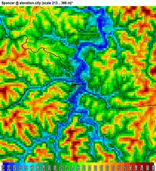
Below is the Elevation map of Spencer, which displays elevation range with different colors. Scale of the first map is from 213 to 366 m (699 to 1201 ft) with average elevation of 284.2 meters (=932 ft) [note 1]
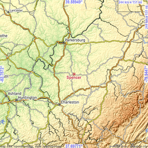
These maps also provides idea of topography and contour of this city, they are displayed at different zoom levels. More info about maps, scale and edge coordinates you can find below images.
| \ | Map #1 | Topo.Map |
| Scale [m] | 213..366 m | × |
| Scale [ft] | 699..1201 ft | × |
| Average | 284.2 m = 932 ft | × |
| Width | 7.62 km = 4.7 mi | 243.7 km = 151.4 mi |
| Height | 7.62 km = 4.7 mi | 243.7 km = 151.4 mi |
| ↑Max Latitude | 38.836269° | 39.88949° |
| Latitude at center | 38.80203° | 38.80203° |
| ↓Min Latitude | 38.767774° | 37.69771° |
| ← Min Longitude | -81.394895° | -82.7572° |
| Longitude center | -81.35095° | -81.35095° |
| →Max Longitude | -81.307005° | -79.9447° |
Nearby cities:
Cities around Spencer sort by population:
• Sissonville elevation 190 m
39 km,  218°
218°
• Ravenswood 187 m
39 km,  294°
294°
• Pinch 223 m
45.2 km,  194°
194°
• Ripley 185 m
31.2 km,  273°
273°
• Mineral Wells 197 m
45.9 km,  340°
340°
• Harrisville 262 m
52.2 km,  29°
29°
• Glenville 224 m
46.8 km,  71°
71°
• Elkview 185 m
41.5 km,  195°
195°
• Clendenin 205 m
34.8 km,  179°
179°
• Elizabeth 196 m
29.3 km,  352°
352°
• Grantsville 216 m
25.9 km,  58°
58°
• Clay 216 m
44.5 km,  148°
148°
Multilingual:
 En español:
Spencer elevación 231 m.
 En France:
Spencer élévation 231 m.


Sources and notes:
- [note 1] Map square and city borders are not equal. Map elevation data is calculated only from area inside that square.
- [src 1] Elevation data from geonames database provided with same terms of usage.
- [src 2] The elevation map of Spencer is generated using elevation data from NASA's 3 arcsec (90m) resolution SRTM data.
- [src 3] Base (background) map © OpenStreetMap contributors tiles are generated by Geofabrik and OpenTopoMap.
Copyright & License:
This Spencer Elevation Map is licensed under CC BY-SA. You may reuse any part from this page, if you give a proper credit by linking to this URL:
 More info on terms of use page.