Weston elevation
Weston (West Virginia, Lewis County), United States elevation is 313 meters and Weston elevation in feet is 1027 ft above sea level [src 1]. Weston is a seat of a second-order administrative division (feature code) with elevation that is 34 meters (112 ft) bigger than average city elevation in United States.
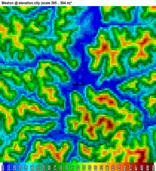
Below is the Elevation map of Weston, which displays elevation range with different colors. Scale of the first map is from 305 to 504 m (1001 to 1654 ft) with average elevation of 371.1 meters (=1218 ft) [note 1]
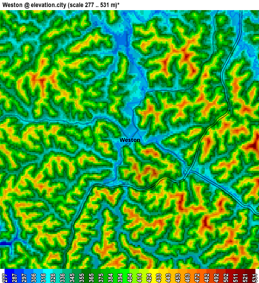
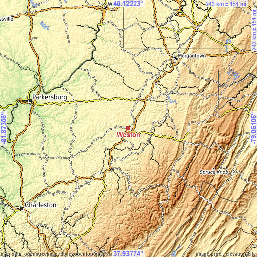
These maps also provides idea of topography and contour of this city, they are displayed at different zoom levels. More info about maps, scale and edge coordinates you can find below images.
| \ | Map #1 | Map #2 | Topo.Map |
| Scale [m] | 305..504 m | 277..531 m | × |
| Scale [ft] | 1001..1654 ft | 909..1742 ft | × |
| Average | 371.1 m = 1218 ft | 378 m = 1240 ft | × |
| Width | 7.59 km = 4.7 mi | 15.18 km = 9.4 mi | 242.9 km = 150.9 mi |
| Height | 7.59 km = 4.7 mi | 15.18 km = 9.4 mi | 242.9 km = 150.9 mi |
| ↑Max Latitude | 39.072555° | 39.106664° | 40.12223° |
| Latitude at center | 39.03843° | 39.03843° | 39.03843° |
| ↓Min Latitude | 39.004288° | 38.97013° | 37.93774° |
| ← Min Longitude | -80.511255° | -80.555201° | -81.87356° |
| Longitude center | -80.46731° | -80.46731° | -80.46731° |
| →Max Longitude | -80.423365° | -80.379419° | -79.06106° |
Nearby cities:
Cities around Weston sort by population:
• Clarksburg elevation 306 m
28.9 km,  21°
21°
• Bridgeport 311 m
33 km,  33°
33°
• Buckhannon 437 m
20.9 km,  103°
103°
• Philippi 398 m
39 km,  71°
71°
• Bethlehem 292 m
42.5 km, 22°
• Shinnston 281 m
42.2 km, 19°
• Stonewood 315 m
27.1 km, 29°
• Nutter Fort 322 m
28.1 km, 26°
• Salem 322 m
28.3 km,  343°
343°
• Glenville 224 m
34 km,  250°
250°
• Despard 318 m
31.1 km, 26°
• West Union 240 m
39.2 km,  317°
317°
Multilingual:
 En español:
Weston elevación 313 m.
 En France:
Weston élévation 313 m.


Sources and notes:
- [note 1] Map square and city borders are not equal. Map elevation data is calculated only from area inside that square.
- [src 1] Elevation data from geonames database provided with same terms of usage.
- [src 2] The elevation map of Weston is generated using elevation data from NASA's 3 arcsec (90m) resolution SRTM data.
- [src 3] Base (background) map © OpenStreetMap contributors tiles are generated by Geofabrik and OpenTopoMap.
Copyright & License:
This Weston Elevation Map is licensed under CC BY-SA. You may reuse any part from this page, if you give a proper credit by linking to this URL:
 More info on terms of use page.