Bridgeport elevation
Bridgeport (West Virginia, Harrison County), United States elevation is 311 meters and Bridgeport elevation in feet is 1020 ft above sea level [src 1]. Bridgeport is a populated place (feature code) with elevation that is 32 meters (105 ft) bigger than average city elevation in United States.
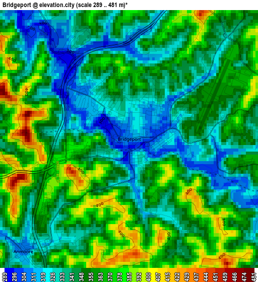
Below is the Elevation map of Bridgeport, which displays elevation range with different colors. Scale of the first map is from 289 to 481 m (948 to 1578 ft) with average elevation of 352.1 meters (=1155 ft) [note 1]
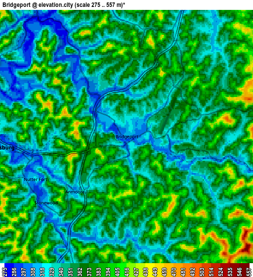
These maps also provides idea of topography and contour of this city, they are displayed at different zoom levels. More info about maps, scale and edge coordinates you can find below images.
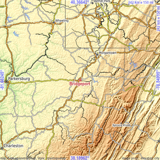
| \ | Map #1 | Map #2 | Topo.Map |
| Scale [m] | 289..481 m | 275..557 m | × |
| Scale [ft] | 948..1578 ft | 902..1827 ft | × |
| Average | 352.1 m = 1155 ft | 359.7 m = 1180 ft | × |
| Width | 7.56 km = 4.7 mi | 15.13 km = 9.4 mi | 242 km = 150.4 mi |
| Height | 7.56 km = 4.7 mi | 15.13 km = 9.4 mi | 242 km = 150.4 mi |
| ↑Max Latitude | 39.320485° | 39.354473° | 40.36642° |
| Latitude at center | 39.28648° | 39.28648° | 39.28648° |
| ↓Min Latitude | 39.252459° | 39.218421° | 38.18962° |
| ← Min Longitude | -80.300145° | -80.344091° | -81.66245° |
| Longitude center | -80.2562° | -80.2562° | -80.2562° |
| →Max Longitude | -80.212255° | -80.168309° | -78.84995° |
Nearby cities:
Cities around Bridgeport sort by population:
• Fairmont elevation 302 m
24.1 km,  23°
23°
• Clarksburg 306 m
7.6 km,  265°
265°
• Grafton 313 m
21.3 km,  73°
73°
• Philippi 398 m
23.8 km,  128°
128°
• Pleasant Valley 314 m
21.2 km,  27°
27°
• Bethlehem 292 m
11.9 km,  349°
349°
• Shinnston 281 m
12.7 km,  342°
342°
• Stonewood 315 m
6.2 km,  230°
230°
• Nutter Fort 322 m
6 km,  244°
244°
• Barrackville 291 m
25.3 km, 17°
• Monongah 296 m
19.9 km,  9°
9°
• Despard 318 m
4.3 km, 273°
Multilingual:
 En español:
Bridgeport elevación 311 m.
 En France:
Bridgeport élévation 311 m.
 Auf Deutsch:
Bridgeport höhe über dem Meeresspiegel ist 311 m.

Sources and notes:
- [note 1] Map square and city borders are not equal. Map elevation data is calculated only from area inside that square.
- [src 1] Elevation data from geonames database provided with same terms of usage.
- [src 2] The elevation map of Bridgeport is generated using elevation data from NASA's 3 arcsec (90m) resolution SRTM data.
- [src 3] Base (background) map © OpenStreetMap contributors tiles are generated by Geofabrik and OpenTopoMap.
Copyright & License:
This Bridgeport Elevation Map is licensed under CC BY-SA. You may reuse any part from this page, if you give a proper credit by linking to this URL:
 More info on terms of use page.