Hohenwald elevation
Hohenwald (Tennessee, Lewis County), United States elevation is 299 meters and Hohenwald elevation in feet is 981 ft above sea level [src 1]. Hohenwald is a seat of a second-order administrative division (feature code) with elevation that is 20 meters (66 ft) bigger than average city elevation in United States.
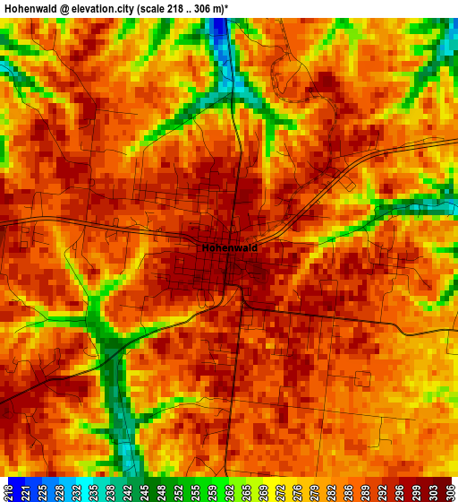
Below is the Elevation map of Hohenwald, which displays elevation range with different colors. Scale of the first map is from 218 to 306 m (715 to 1004 ft) with average elevation of 282.8 meters (=928 ft) [note 1]
These maps also provides idea of topography and contour of this city, they are displayed at different zoom levels. More info about maps, scale and edge coordinates you can find below images.

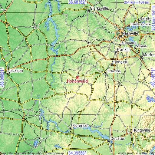
| \ | Map #1 | Map #2 | Topo.Map |
| Scale [m] | 218..306 m | 178..310 m | × |
| Scale [ft] | 715..1004 ft | 584..1017 ft | × |
| Average | 282.8 m = 928 ft | 266.4 m = 874 ft | × |
| Width | 7.95 km = 4.9 mi | 15.9 km = 9.9 mi | 254.4 km = 158.1 mi |
| Height | 7.95 km = 4.9 mi | 15.9 km = 9.9 mi | 254.4 km = 158.1 mi |
| ↑Max Latitude | 35.583597° | 35.619329° | 36.68382° |
| Latitude at center | 35.54785° | 35.54785° | 35.54785° |
| ↓Min Latitude | 35.512087° | 35.476308° | 34.39556° |
| ← Min Longitude | -87.595905° | -87.639851° | -88.95821° |
| Longitude center | -87.55196° | -87.55196° | -87.55196° |
| →Max Longitude | -87.508015° | -87.464069° | -86.14571° |
Nearby cities:
Cities around Hohenwald sort by population:
• Columbia elevation 199 m
47.3 km,  80°
80°
• Lawrenceburg 274 m
39.3 km,  149°
149°
• Mount Carmel 139 m
41.6 km,  262°
262°
• Mount Pleasant 205 m
31.3 km,  92°
92°
• Centerville 192 m
26.8 km,  16°
16°
• Clifton 124 m
44 km,  245°
245°
• Waynesboro 231 m
31.7 km,  216°
216°
• Parsons 153 m
53.2 km,  282°
282°
• Loretto 250 m
53.2 km,  168°
168°
• Bon Aqua Junction 278 m
47.5 km,  27°
27°
• Linden 172 m
27.1 km,  286°
286°
• Decaturville 159 m
51.5 km,  274°
274°
Multilingual:
 En español:
Hohenwald elevación 299 m.
 En France:
Hohenwald élévation 299 m.
 Auf Deutsch:
Hohenwald höhe über dem Meeresspiegel ist 299 m.

Sources and notes:
- [note 1] Map square and city borders are not equal. Map elevation data is calculated only from area inside that square.
- [src 1] Elevation data from geonames database provided with same terms of usage.
- [src 2] The elevation map of Hohenwald is generated using elevation data from NASA's 3 arcsec (90m) resolution SRTM data.
- [src 3] Base (background) map © OpenStreetMap contributors tiles are generated by Geofabrik and OpenTopoMap.
Copyright & License:
This Hohenwald Elevation Map is licensed under CC BY-SA. You may reuse any part from this page, if you give a proper credit by linking to this URL:
 More info on terms of use page.