Linden elevation
Linden (Tennessee, Perry County), United States elevation is 172 meters and Linden elevation in feet is 564 ft above sea level [src 1]. Linden is a seat of a second-order administrative division (feature code) with elevation that is 107 meters (351 ft) smaller than average city elevation in United States.
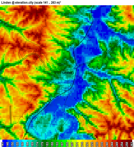
Below is the Elevation map of Linden, which displays elevation range with different colors. Scale of the first map is from 141 to 263 m (463 to 863 ft) with average elevation of 197.6 meters (=648 ft) [note 1]
These maps also provides idea of topography and contour of this city, they are displayed at different zoom levels. More info about maps, scale and edge coordinates you can find below images.
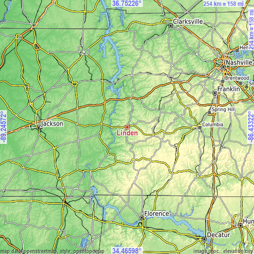
| \ | Map #1 | Topo.Map |
| Scale [m] | 141..263 m | × |
| Scale [ft] | 463..863 ft | × |
| Average | 197.6 m = 648 ft | × |
| Width | 7.94 km = 4.9 mi | 254.2 km = 158 mi |
| Height | 7.94 km = 4.9 mi | 254.2 km = 158 mi |
| ↑Max Latitude | 35.653006° | 36.75226° |
| Latitude at center | 35.61729° | 35.61729° |
| ↓Min Latitude | 35.581558° | 34.46598° |
| ← Min Longitude | -87.883415° | -89.24572° |
| Longitude center | -87.83947° | -87.83947° |
| →Max Longitude | -87.795525° | -86.43322° |
Nearby cities:
Cities around Linden sort by population:
• Lexington elevation 161 m
50.2 km,  274°
274°
• Mount Carmel 139 m
20.2 km,  228°
228°
• Waverly 161 m
52 km,  4°
4°
• Hohenwald 299 m
27.1 km,  106°
106°
• Centerville 192 m
38.1 km,  61°
61°
• Camden 141 m
54.3 km,  334°
334°
• Clifton 124 m
29.2 km,  208°
208°
• Waynesboro 231 m
33.8 km,  168°
168°
• Parsons 153 m
26.2 km,  277°
277°
• New Johnsonville 131 m
46.4 km,  345°
345°
• Johnsonville 112 m
50.3 km, 348°
• Decaturville 159 m
25.6 km,  261°
261°
Multilingual:
 En español:
Linden elevación 172 m.
 En France:
Linden élévation 172 m.


Sources and notes:
- [note 1] Map square and city borders are not equal. Map elevation data is calculated only from area inside that square.
- [src 1] Elevation data from geonames database provided with same terms of usage.
- [src 2] The elevation map of Linden is generated using elevation data from NASA's 3 arcsec (90m) resolution SRTM data.
- [src 3] Base (background) map © OpenStreetMap contributors tiles are generated by Geofabrik and OpenTopoMap.
Copyright & License:
This Linden Elevation Map is licensed under CC BY-SA. You may reuse any part from this page, if you give a proper credit by linking to this URL:
 More info on terms of use page.