Mount Carmel elevation
Mount Carmel (Tennessee, Decatur County), United States elevation is 139 meters and Mount Carmel elevation in feet is 456 ft above sea level [src 1]. Mount Carmel is a populated place (feature code) with elevation that is 140 meters (459 ft) smaller than average city elevation in United States.
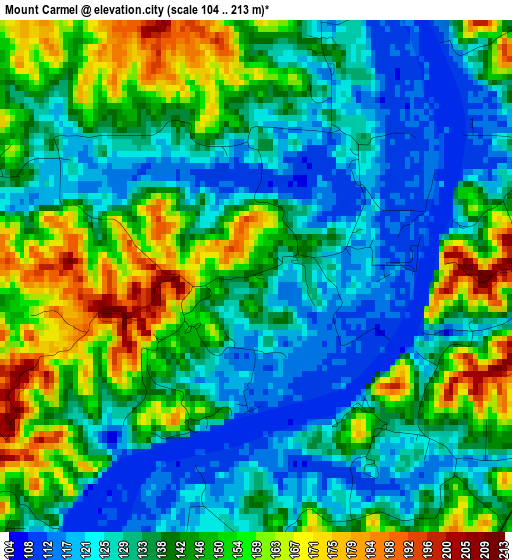
Below is the Elevation map of Mount Carmel, which displays elevation range with different colors. Scale of the first map is from 104 to 213 m (341 to 699 ft) with average elevation of 139.4 meters (=457 ft) [note 1]
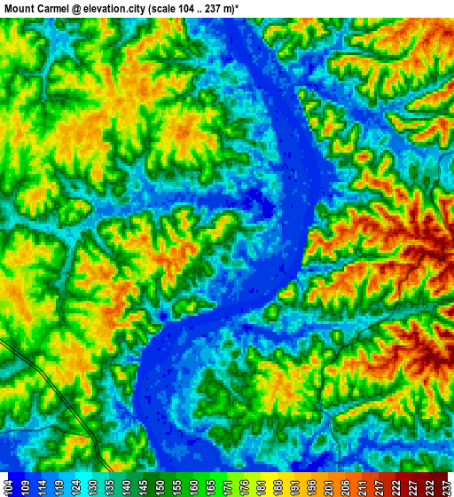
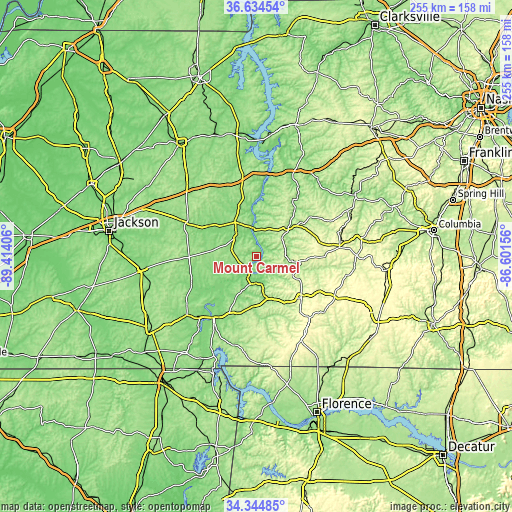
These maps also provides idea of topography and contour of this city, they are displayed at different zoom levels. More info about maps, scale and edge coordinates you can find below images.
| \ | Map #1 | Map #2 | Topo.Map |
| Scale [m] | 104..213 m | 104..237 m | × |
| Scale [ft] | 341..699 ft | 341..778 ft | × |
| Average | 139.4 m = 457 ft | 153.1 m = 502 ft | × |
| Width | 7.96 km = 4.9 mi | 15.91 km = 9.9 mi | 254.6 km = 158.2 mi |
| Height | 7.96 km = 4.9 mi | 15.91 km = 9.9 mi | 254.6 km = 158.2 mi |
| ↑Max Latitude | 35.53362° | 35.569373° | 36.63454° |
| Latitude at center | 35.49785° | 35.49785° | 35.49785° |
| ↓Min Latitude | 35.462065° | 35.426263° | 34.34485° |
| ← Min Longitude | -88.051755° | -88.095701° | -89.41406° |
| Longitude center | -88.00781° | -88.00781° | -88.00781° |
| →Max Longitude | -87.963865° | -87.919919° | -86.60156° |
Nearby cities:
Cities around Mount Carmel sort by population:
• Lexington elevation 161 m
38.8 km,  296°
296°
• Savannah 135 m
37.4 km,  215°
215°
• Henderson 137 m
57.7 km,  263°
263°
• Hohenwald 299 m
41.6 km,  82°
82°
• Clifton 124 m
12.4 km,  174°
174°
• Waynesboro 231 m
29.8 km,  131°
131°
• Parsons 153 m
20 km,  327°
327°
• Adamsville 160 m
45.3 km,  229°
229°
• Crump 140 m
41.6 km, 222°
• Olivet 141 m
36 km,  208°
208°
• Linden 172 m
20.2 km,  48°
48°
• Decaturville 159 m
13.9 km,  313°
313°
Multilingual:
 En español:
Mount Carmel elevación 139 m.
 En France:
Mount Carmel élévation 139 m.
 Auf Deutsch:
Mount Carmel höhe über dem Meeresspiegel ist 139 m.

Sources and notes:
- [note 1] Map square and city borders are not equal. Map elevation data is calculated only from area inside that square.
- [src 1] Elevation data from geonames database provided with same terms of usage.
- [src 2] The elevation map of Mount Carmel is generated using elevation data from NASA's 3 arcsec (90m) resolution SRTM data.
- [src 3] Base (background) map © OpenStreetMap contributors tiles are generated by Geofabrik and OpenTopoMap.
Copyright & License:
This Mount Carmel Elevation Map is licensed under CC BY-SA. You may reuse any part from this page, if you give a proper credit by linking to this URL:
 More info on terms of use page.