Columbia elevation
Columbia (Tennessee, Maury County), United States elevation is 199 meters and Columbia elevation in feet is 653 ft above sea level [src 1]. Columbia is a seat of a second-order administrative division (feature code) with elevation that is 80 meters (262 ft) smaller than average city elevation in United States.
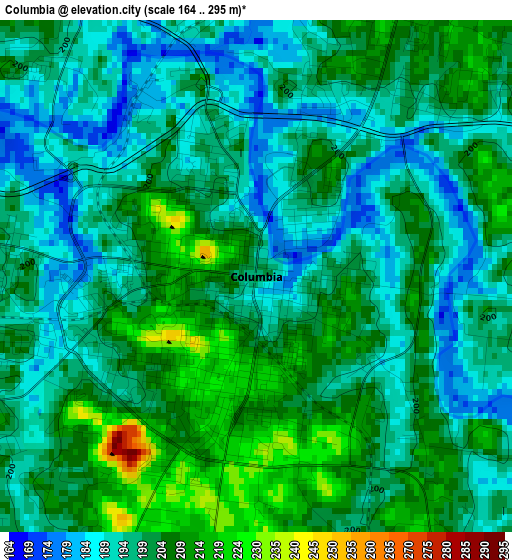
Below is the Elevation map of Columbia, which displays elevation range with different colors. Scale of the first map is from 164 to 295 m (538 to 968 ft) with average elevation of 200.3 meters (=657 ft) [note 1]
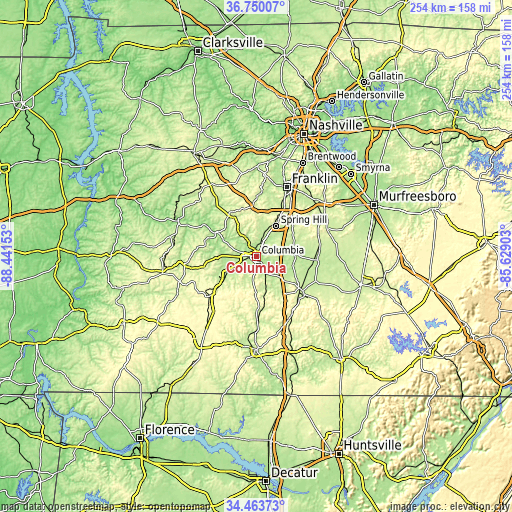
These maps also provides idea of topography and contour of this city, they are displayed at different zoom levels. More info about maps, scale and edge coordinates you can find below images.
| \ | Map #1 | Map #2 | Topo.Map |
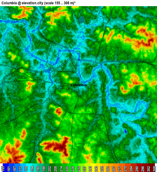
| Scale [m] | 164..295 m | 155..308 m | × |
| Scale [ft] | 538..968 ft | 509..1010 ft | × |
| Average | 200.3 m = 657 ft | 209.5 m = 687 ft | × |
| Width | 7.94 km = 4.9 mi | 15.89 km = 9.9 mi | 254.2 km = 158 mi |
| Height | 7.94 km = 4.9 mi | 15.89 km = 9.9 mi | 254.2 km = 158 mi |
| ↑Max Latitude | 35.650787° | 35.686489° | 36.75007° |
| Latitude at center | 35.61507° | 35.61507° | 35.61507° |
| ↓Min Latitude | 35.579337° | 35.543588° | 34.46373° |
| ← Min Longitude | -87.079225° | -87.123171° | -88.44153° |
| Longitude center | -87.03528° | -87.03528° | -87.03528° |
| →Max Longitude | -86.991335° | -86.947389° | -85.62903° |
Nearby cities:
Cities around Columbia sort by population:
• Franklin elevation 201 m
37.6 km,  23°
23°
• Spring Hill 231 m
17.9 km,  32°
32°
• Lewisburg 226 m
28.9 km,  129°
129°
• Fairview 251 m
41.5 km,  349°
349°
• Pulaski 222 m
46.2 km,  179°
179°
• Mount Pleasant 205 m
17.9 km,  239°
239°
• Thompson's Station 249 m
23.6 km, 28°
• Centerville 192 m
43 km,  295°
295°
• Chapel Hill 211 m
30.9 km,  87°
87°
• Unionville 221 m
40 km, 88°
• Bon Aqua Junction 278 m
42.7 km,  324°
324°
• Cornersville 271 m
33.3 km,  147°
147°
Multilingual:
 En español:
Columbia elevación 199 m.
 En France:
Columbia élévation 199 m.
 Auf Deutsch:
Columbia höhe über dem Meeresspiegel ist 199 m.

Sources and notes:
- [note 1] Map square and city borders are not equal. Map elevation data is calculated only from area inside that square.
- [src 1] Elevation data from geonames database provided with same terms of usage.
- [src 2] The elevation map of Columbia is generated using elevation data from NASA's 3 arcsec (90m) resolution SRTM data.
- [src 3] Base (background) map © OpenStreetMap contributors tiles are generated by Geofabrik and OpenTopoMap.
Copyright & License:
This Columbia Elevation Map is licensed under CC BY-SA. You may reuse any part from this page, if you give a proper credit by linking to this URL:
 More info on terms of use page.