Loretto elevation
Loretto (Tennessee, Lawrence County), United States elevation is 250 meters and Loretto elevation in feet is 820 ft above sea level [src 1]. Loretto is a populated place (feature code) with elevation that is 29 meters (95 ft) smaller than average city elevation in United States.
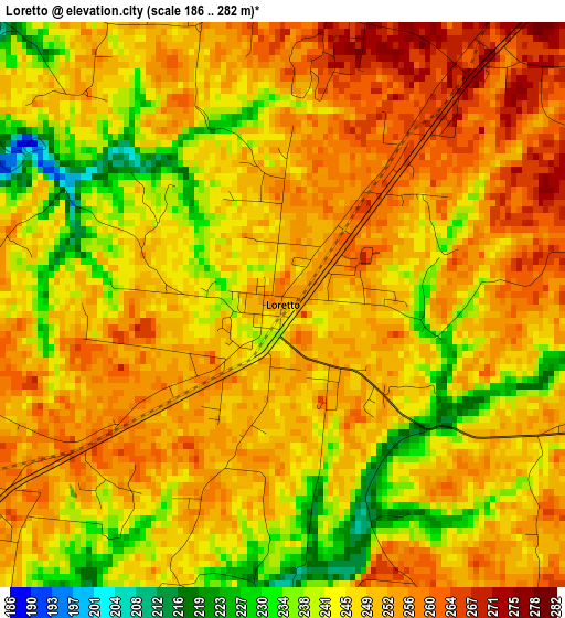
Below is the Elevation map of Loretto, which displays elevation range with different colors. Scale of the first map is from 186 to 282 m (610 to 925 ft) with average elevation of 248.4 meters (=815 ft) [note 1]
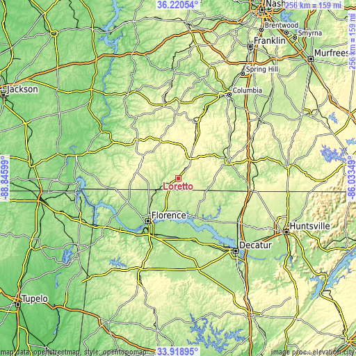
These maps also provides idea of topography and contour of this city, they are displayed at different zoom levels. More info about maps, scale and edge coordinates you can find below images.
| \ | Map #1 | Topo.Map |
| Scale [m] | 186..282 m | × |
| Scale [ft] | 610..925 ft | × |
| Average | 248.4 m = 815 ft | × |
| Width | 8 km = 5 mi | 255.9 km = 159 mi |
| Height | 8 km = 5 mi | 255.9 km = 159 mi |
| ↑Max Latitude | 35.113816° | 36.22054° |
| Latitude at center | 35.07786° | 35.07786° |
| ↓Min Latitude | 35.041888° | 33.91895° |
| ← Min Longitude | -87.483685° | -88.84599° |
| Longitude center | -87.43974° | -87.43974° |
| →Max Longitude | -87.395795° | -86.03349° |
Nearby cities:
Cities around Loretto sort by population:
• Florence elevation 172 m
37.7 km,  215°
215°
• East Florence 171 m
35.4 km,  212°
212°
• Muscle Shoals 153 m
42.5 km, 209°
• Lawrenceburg 274 m
20.6 km,  27°
27°
• Sheffield 160 m
42 km, 214°
• Tuscumbia 143 m
45.4 km, 211°
• Pulaski 222 m
39.6 km,  69°
69°
• Underwood-Petersville 196 m
32.4 km,  226°
226°
• Waynesboro 231 m
39.8 km,  312°
312°
• Rogersville 194 m
30.9 km,  155°
155°
• Town Creek 174 m
44.2 km,  176°
176°
• Washington Street Courthouse Annex 216 m
52.4 km,  125°
125°
Multilingual:
 En español:
Loretto elevación 250 m.
 En France:
Loretto élévation 250 m.


Sources and notes:
- [note 1] Map square and city borders are not equal. Map elevation data is calculated only from area inside that square.
- [src 1] Elevation data from geonames database provided with same terms of usage.
- [src 2] The elevation map of Loretto is generated using elevation data from NASA's 3 arcsec (90m) resolution SRTM data.
- [src 3] Base (background) map © OpenStreetMap contributors tiles are generated by Geofabrik and OpenTopoMap.
Copyright & License:
This Loretto Elevation Map is licensed under CC BY-SA. You may reuse any part from this page, if you give a proper credit by linking to this URL:
 More info on terms of use page.