Sheffield elevation
Sheffield (Alabama, Colbert County), United States elevation is 160 meters and Sheffield elevation in feet is 525 ft above sea level [src 1]. Sheffield is a populated place (feature code) with elevation that is 119 meters (390 ft) smaller than average city elevation in United States.
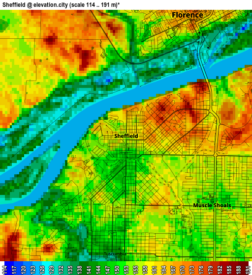
Below is the Elevation map of Sheffield, which displays elevation range with different colors. Scale of the first map is from 114 to 191 m (374 to 627 ft) with average elevation of 152.4 meters (=500 ft) [note 1]
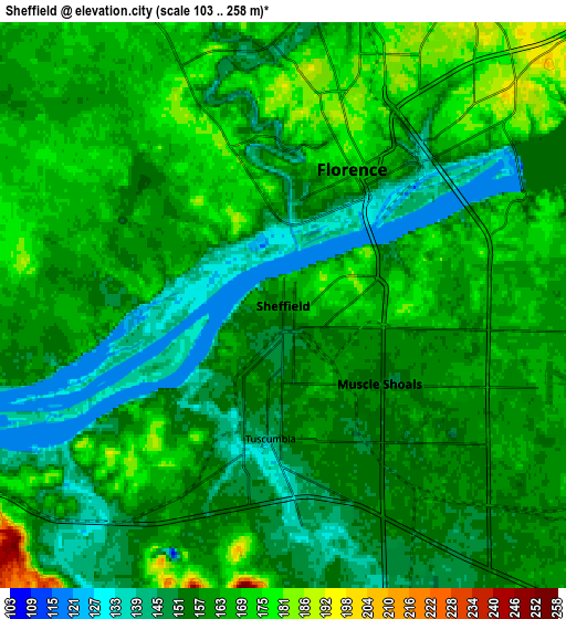
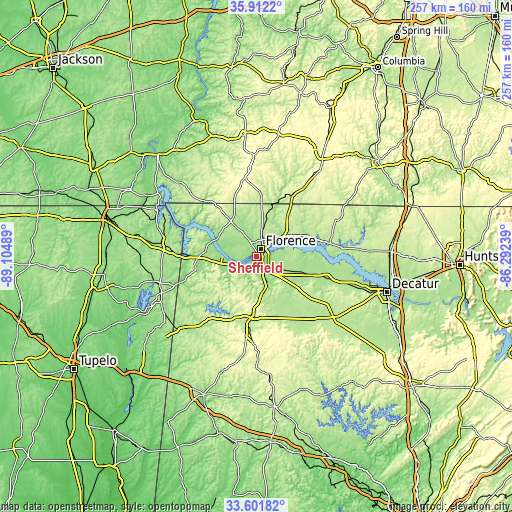
These maps also provides idea of topography and contour of this city, they are displayed at different zoom levels. More info about maps, scale and edge coordinates you can find below images.
| \ | Map #1 | Map #2 | Topo.Map |
| Scale [m] | 114..191 m | 103..258 m | × |
| Scale [ft] | 374..627 ft | 338..846 ft | × |
| Average | 152.4 m = 500 ft | 159 m = 522 ft | × |
| Width | 8.03 km = 5 mi | 16.06 km = 10 mi | 256.9 km = 159.6 mi |
| Height | 8.03 km = 5 mi | 16.06 km = 10 mi | 256.9 km = 159.6 mi |
| ↑Max Latitude | 34.801183° | 34.83726° | 35.9122° |
| Latitude at center | 34.76509° | 34.76509° | 34.76509° |
| ↓Min Latitude | 34.728981° | 34.692857° | 33.60182° |
| ← Min Longitude | -87.742585° | -87.786531° | -89.10489° |
| Longitude center | -87.69864° | -87.69864° | -87.69864° |
| →Max Longitude | -87.654695° | -87.610749° | -86.29239° |
Nearby cities:
Cities around Sheffield sort by population:
• Florence elevation 172 m
4.3 km,  26°
26°
• East Florence 171 m
6.7 km,  42°
42°
• Muscle Shoals 153 m
3.6 km,  128°
128°
• Russellville 234 m
28.7 km,  185°
185°
• Tuscumbia 143 m
3.8 km, 185°
• Underwood-Petersville 196 m
12.4 km,  0°
0°
• Iuka 176 m
45.2 km,  276°
276°
• Loretto 250 m
42 km, 34°
• Phil Campbell 313 m
46.1 km,  180°
180°
• Rogersville 194 m
37.3 km,  79°
79°
• Town Creek 174 m
28.3 km,  109°
109°
• Cherokee 161 m
25.1 km,  267°
267°
Multilingual:
 En español:
Sheffield elevación 160 m.
 En France:
Sheffield élévation 160 m.
 Auf Deutsch:
Sheffield höhe über dem Meeresspiegel ist 160 m.

Sources and notes:
- [note 1] Map square and city borders are not equal. Map elevation data is calculated only from area inside that square.
- [src 1] Elevation data from geonames database provided with same terms of usage.
- [src 2] The elevation map of Sheffield is generated using elevation data from NASA's 3 arcsec (90m) resolution SRTM data.
- [src 3] Base (background) map © OpenStreetMap contributors tiles are generated by Geofabrik and OpenTopoMap.
Copyright & License:
This Sheffield Elevation Map is licensed under CC BY-SA. You may reuse any part from this page, if you give a proper credit by linking to this URL:
 More info on terms of use page.