Leitchfield elevation
Leitchfield (Kentucky, Grayson County), United States elevation is 229 meters and Leitchfield elevation in feet is 751 ft above sea level [src 1]. Leitchfield is a seat of a second-order administrative division (feature code) with elevation that is 50 meters (164 ft) smaller than average city elevation in United States.
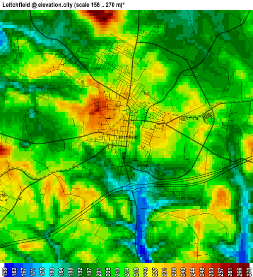
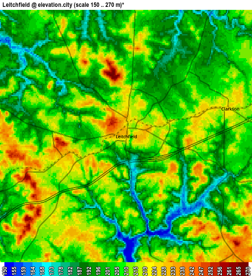
Below is the Elevation map of Leitchfield, which displays elevation range with different colors. Scale of the first map is from 158 to 270 m (518 to 886 ft) with average elevation of 208.3 meters (=683 ft) [note 1]
These maps also provides idea of topography and contour of this city, they are displayed at different zoom levels. More info about maps, scale and edge coordinates you can find below images.
| \ | Map #1 | Map #2 | Topo.Map |
| Scale [m] | 158..270 m | 150..270 m | × |
| Scale [ft] | 518..886 ft | 492..886 ft | × |
| Average | 208.3 m = 683 ft | 205.8 m = 675 ft | × |
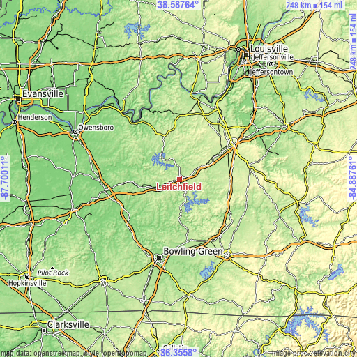
| Width | 7.76 km = 4.8 mi | 15.51 km = 9.6 mi | 248.2 km = 154.2 mi |
| Height | 7.76 km = 4.8 mi | 15.51 km = 9.6 mi | 248.2 km = 154.2 mi |
| ↑Max Latitude | 37.514915° | 37.549764° | 38.58764° |
| Latitude at center | 37.48005° | 37.48005° | 37.48005° |
| ↓Min Latitude | 37.445168° | 37.410271° | 36.3558° |
| ← Min Longitude | -86.337805° | -86.381751° | -87.70011° |
| Longitude center | -86.29386° | -86.29386° | -86.29386° |
| →Max Longitude | -86.249915° | -86.205969° | -84.88761° |
Nearby cities:
Cities around Leitchfield sort by population:
• Elizabethtown elevation 222 m
45.1 km,  58°
58°
• Oak Grove 160 m
43.4 km,  249°
249°
• Vine Grove 210 m
45.9 km,  36°
36°
• Hodgenville 222 m
49.9 km,  77°
77°
• Morgantown 173 m
44.6 km,  230°
230°
• Cave City 195 m
48.4 km,  142°
142°
• Horse Cave 194 m
47.8 km,  134°
134°
• Hardinsburg 216 m
36.4 km,  336°
336°
• Munfordville 191 m
42.4 km,  122°
122°
• Irvington 192 m
44.5 km,  1°
1°
• Cloverport 154 m
49.3 km,  322°
322°
• Brownsville 169 m
32.1 km,  175°
175°
Multilingual:
 En español:
Leitchfield elevación 229 m.
 En France:
Leitchfield élévation 229 m.
 Auf Deutsch:
Leitchfield höhe über dem Meeresspiegel ist 229 m.

Sources and notes:
- [note 1] Map square and city borders are not equal. Map elevation data is calculated only from area inside that square.
- [src 1] Elevation data from geonames database provided with same terms of usage.
- [src 2] The elevation map of Leitchfield is generated using elevation data from NASA's 3 arcsec (90m) resolution SRTM data.
- [src 3] Base (background) map © OpenStreetMap contributors tiles are generated by Geofabrik and OpenTopoMap.
Copyright & License:
This Leitchfield Elevation Map is licensed under CC BY-SA. You may reuse any part from this page, if you give a proper credit by linking to this URL:
 More info on terms of use page.