Morgantown elevation
Morgantown (Kentucky, Butler County), United States elevation is 173 meters and Morgantown elevation in feet is 568 ft above sea level [src 1]. Morgantown is a seat of a second-order administrative division (feature code) with elevation that is 106 meters (348 ft) smaller than average city elevation in United States.
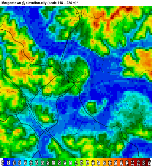
Below is the Elevation map of Morgantown, which displays elevation range with different colors. Scale of the first map is from 118 to 224 m (387 to 735 ft) with average elevation of 149.8 meters (=491 ft) [note 1]
These maps also provides idea of topography and contour of this city, they are displayed at different zoom levels. More info about maps, scale and edge coordinates you can find below images.
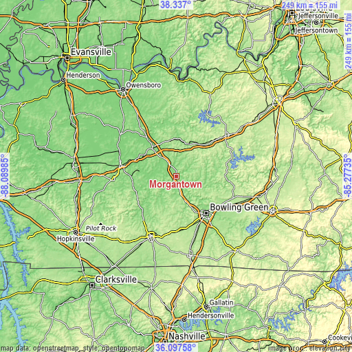
| \ | Map #1 | Topo.Map |
| Scale [m] | 118..224 m | × |
| Scale [ft] | 387..735 ft | × |
| Average | 149.8 m = 491 ft | × |
| Width | 7.78 km = 4.8 mi | 249 km = 154.7 mi |
| Height | 7.78 km = 4.8 mi | 249 km = 154.7 mi |
| ↑Max Latitude | 37.260584° | 38.337° |
| Latitude at center | 37.2256° | 37.2256° |
| ↓Min Latitude | 37.1906° | 36.09758° |
| ← Min Longitude | -86.727545° | -88.08985° |
| Longitude center | -86.6836° | -86.6836° |
| →Max Longitude | -86.639655° | -85.27735° |
Nearby cities:
Cities around Morgantown sort by population:
• Bowling Green elevation 163 m
33.7 km,  140°
140°
• Oak Grove 160 m
14.6 km,  334°
334°
• Morehead 160 m
43.9 km,  276°
276°
• Russellville 185 m
46 km,  203°
203°
• Leitchfield 229 m
44.6 km,  50°
50°
• Central City 136 m
39.6 km, 281°
• Greenville 164 m
43.9 km,  266°
266°
• Beaver Dam 124 m
26 km,  319°
319°
• Hartford 127 m
32 km, 321°
• Auburn 197 m
40.3 km,  183°
183°
• Plano 186 m
45 km,  148°
148°
• Brownsville 169 m
37 km,  95°
95°
Multilingual:
 En español:
Morgantown elevación 173 m.
 En France:
Morgantown élévation 173 m.
 Auf Deutsch:
Morgantown höhe über dem Meeresspiegel ist 173 m.

Sources and notes:
- [note 1] Map square and city borders are not equal. Map elevation data is calculated only from area inside that square.
- [src 1] Elevation data from geonames database provided with same terms of usage.
- [src 2] The elevation map of Morgantown is generated using elevation data from NASA's 3 arcsec (90m) resolution SRTM data.
- [src 3] Base (background) map © OpenStreetMap contributors tiles are generated by Geofabrik and OpenTopoMap.
Copyright & License:
This Morgantown Elevation Map is licensed under CC BY-SA. You may reuse any part from this page, if you give a proper credit by linking to this URL:
 More info on terms of use page.