Beaver Dam elevation
Beaver Dam (Kentucky, Ohio County), United States elevation is 124 meters and Beaver Dam elevation in feet is 407 ft above sea level [src 1]. Beaver Dam is a populated place (feature code) with elevation that is 155 meters (509 ft) smaller than average city elevation in United States.
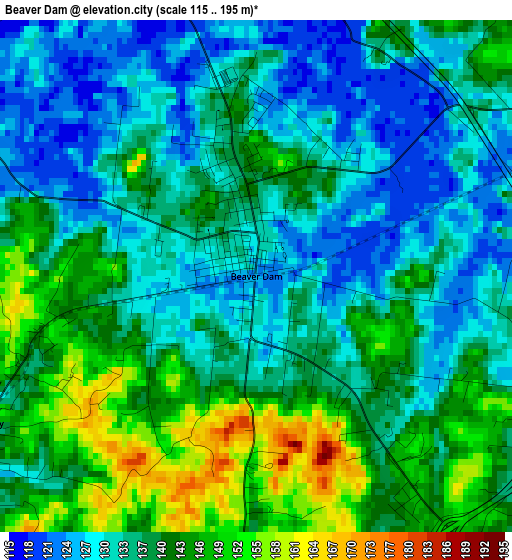
Below is the Elevation map of Beaver Dam, which displays elevation range with different colors. Scale of the first map is from 115 to 195 m (377 to 640 ft) with average elevation of 137.2 meters (=450 ft) [note 1]
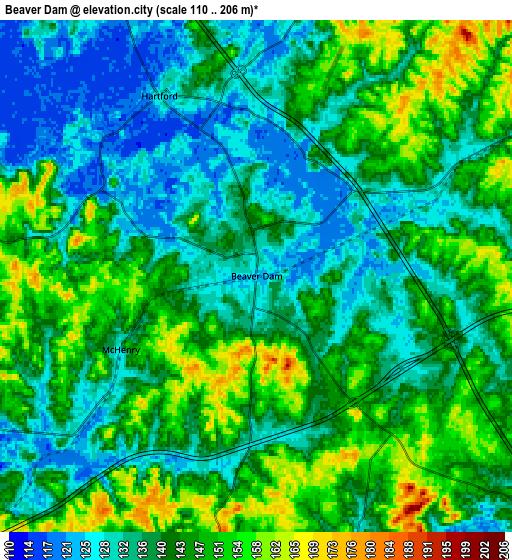
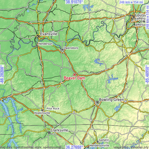
These maps also provides idea of topography and contour of this city, they are displayed at different zoom levels. More info about maps, scale and edge coordinates you can find below images.
| \ | Map #1 | Map #2 | Topo.Map |
| Scale [m] | 115..195 m | 110..206 m | × |
| Scale [ft] | 377..640 ft | 361..676 ft | × |
| Average | 137.2 m = 450 ft | 140.6 m = 461 ft | × |
| Width | 7.76 km = 4.8 mi | 15.53 km = 9.6 mi | 248.4 km = 154.3 mi |
| Height | 7.76 km = 4.8 mi | 15.53 km = 9.6 mi | 248.4 km = 154.3 mi |
| ↑Max Latitude | 37.436892° | 37.471777° | 38.51075° |
| Latitude at center | 37.40199° | 37.40199° | 37.40199° |
| ↓Min Latitude | 37.367072° | 37.332138° | 36.27658° |
| ← Min Longitude | -86.919775° | -86.963721° | -88.28208° |
| Longitude center | -86.87583° | -86.87583° | -86.87583° |
| →Max Longitude | -86.831885° | -86.787939° | -85.46958° |
Nearby cities:
Cities around Beaver Dam sort by population:
• Owensboro elevation 125 m
46.4 km,  333°
333°
• Oak Grove 160 m
12.5 km,  120°
120°
• Morehead 160 m
30.3 km,  241°
241°
• Leitchfield 229 m
52.1 km,  80°
80°
• Knottsville 170 m
41.2 km,  356°
356°
• Central City 136 m
25 km, 241°
• Greenville 164 m
34.9 km,  230°
230°
• Hartford 127 m
6.2 km, 331°
• Morgantown 173 m
26 km,  139°
139°
• Livermore 127 m
24.8 km,  294°
294°
• Masonville 129 m
33.4 km,  335°
335°
• Calhoun 121 m
37 km, 294°
Multilingual:
 En español:
Beaver Dam elevación 124 m.
 En France:
Beaver Dam élévation 124 m.
 Auf Deutsch:
Beaver Dam höhe über dem Meeresspiegel ist 124 m.

Sources and notes:
- [note 1] Map square and city borders are not equal. Map elevation data is calculated only from area inside that square.
- [src 1] Elevation data from geonames database provided with same terms of usage.
- [src 2] The elevation map of Beaver Dam is generated using elevation data from NASA's 3 arcsec (90m) resolution SRTM data.
- [src 3] Base (background) map © OpenStreetMap contributors tiles are generated by Geofabrik and OpenTopoMap.
Copyright & License:
This Beaver Dam Elevation Map is licensed under CC BY-SA. You may reuse any part from this page, if you give a proper credit by linking to this URL:
 More info on terms of use page.