Russellville elevation
Russellville (Kentucky, Logan County), United States elevation is 185 meters and Russellville elevation in feet is 607 ft above sea level [src 1]. Russellville is a seat of a second-order administrative division (feature code) with elevation that is 94 meters (308 ft) smaller than average city elevation in United States.
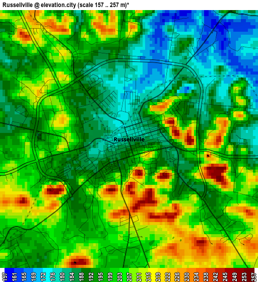
Below is the Elevation map of Russellville, which displays elevation range with different colors. Scale of the first map is from 157 to 257 m (515 to 843 ft) with average elevation of 198 meters (=650 ft) [note 1]
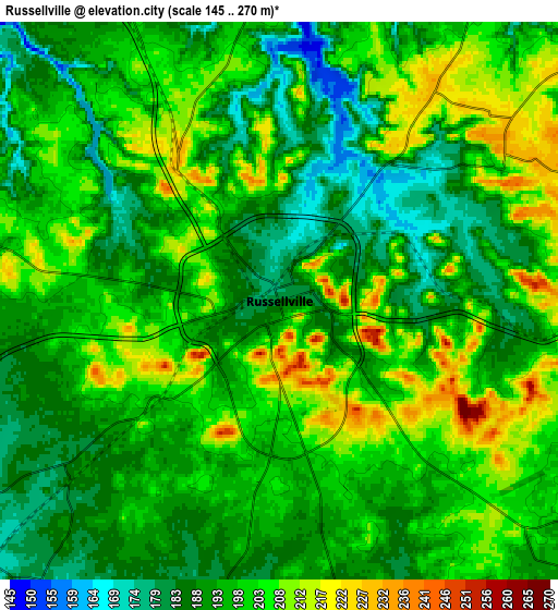
These maps also provides idea of topography and contour of this city, they are displayed at different zoom levels. More info about maps, scale and edge coordinates you can find below images.
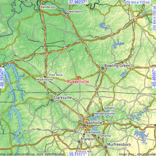
| \ | Map #1 | Map #2 | Topo.Map |
| Scale [m] | 157..257 m | 145..270 m | × |
| Scale [ft] | 515..843 ft | 476..886 ft | × |
| Average | 198 m = 650 ft | 196.8 m = 646 ft | × |
| Width | 7.82 km = 4.9 mi | 15.64 km = 9.7 mi | 250.2 km = 155.5 mi |
| Height | 7.82 km = 4.9 mi | 15.64 km = 9.7 mi | 250.2 km = 155.5 mi |
| ↑Max Latitude | 36.880479° | 36.915623° | 37.96237° |
| Latitude at center | 36.84532° | 36.84532° | 36.84532° |
| ↓Min Latitude | 36.810144° | 36.774953° | 35.71171° |
| ← Min Longitude | -86.931165° | -86.975111° | -88.29347° |
| Longitude center | -86.88722° | -86.88722° | -86.88722° |
| →Max Longitude | -86.843275° | -86.799329° | -85.48097° |
Nearby cities:
Cities around Russellville sort by population:
• Bowling Green elevation 163 m
42.6 km,  67°
67°
• Springfield 204 m
37.4 km,  179°
179°
• Portland 245 m
44.2 km,  131°
131°
• White House 264 m
46.7 km,  153°
153°
• Franklin 219 m
30.8 km,  116°
116°
• Coopertown 223 m
45.9 km,  188°
188°
• Morgantown 173 m
46 km,  23°
23°
• Elkton 190 m
24.1 km,  260°
260°
• Cross Plains 226 m
37.1 km, 152°
• Guthrie 168 m
33.1 km,  228°
228°
• Auburn 197 m
15.9 km,  82°
82°
• Plano 186 m
41.9 km, 84°
Multilingual:
 En español:
Russellville elevación 185 m.
 En France:
Russellville élévation 185 m.
 Auf Deutsch:
Russellville höhe über dem Meeresspiegel ist 185 m.

Sources and notes:
- [note 1] Map square and city borders are not equal. Map elevation data is calculated only from area inside that square.
- [src 1] Elevation data from geonames database provided with same terms of usage.
- [src 2] The elevation map of Russellville is generated using elevation data from NASA's 3 arcsec (90m) resolution SRTM data.
- [src 3] Base (background) map © OpenStreetMap contributors tiles are generated by Geofabrik and OpenTopoMap.
Copyright & License:
This Russellville Elevation Map is licensed under CC BY-SA. You may reuse any part from this page, if you give a proper credit by linking to this URL:
 More info on terms of use page.