White House elevation
White House (Tennessee, Sumner County), United States elevation is 264 meters and White House elevation in feet is 866 ft above sea level [src 1]. White House is a populated place (feature code) with elevation that is 15 meters (49 ft) smaller than average city elevation in United States.
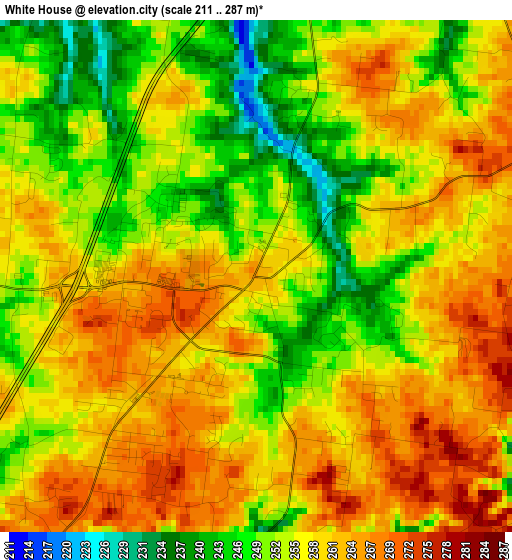
Below is the Elevation map of White House, which displays elevation range with different colors. Scale of the first map is from 211 to 287 m (692 to 942 ft) with average elevation of 256.2 meters (=841 ft) [note 1]
These maps also provides idea of topography and contour of this city, they are displayed at different zoom levels. More info about maps, scale and edge coordinates you can find below images.
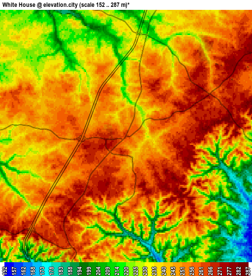
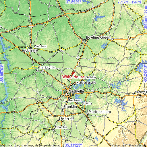
| \ | Map #1 | Map #2 | Topo.Map |
| Scale [m] | 211..287 m | 152..287 m | × |
| Scale [ft] | 692..942 ft | 499..942 ft | × |
| Average | 256.2 m = 841 ft | 242.4 m = 795 ft | × |
| Width | 7.86 km = 4.9 mi | 15.72 km = 9.8 mi | 251.5 km = 156.3 mi |
| Height | 7.86 km = 4.9 mi | 15.72 km = 9.8 mi | 251.5 km = 156.3 mi |
| ↑Max Latitude | 36.505651° | 36.540966° | 37.5929° |
| Latitude at center | 36.47032° | 36.47032° | 36.47032° |
| ↓Min Latitude | 36.434973° | 36.399609° | 35.33125° |
| ← Min Longitude | -86.695325° | -86.739271° | -88.05763° |
| Longitude center | -86.65138° | -86.65138° | -86.65138° |
| →Max Longitude | -86.607435° | -86.563489° | -85.24513° |
Nearby cities:
Cities around White House sort by population:
• Hendersonville elevation 148 m
18.6 km,  171°
171°
• Gallatin 168 m
20.5 km,  116°
116°
• Goodlettsville 145 m
17.3 km,  198°
198°
• Springfield 204 m
21.3 km,  281°
281°
• Portland 245 m
17.3 km,  44°
44°
• Greenbrier 260 m
14.5 km,  250°
250°
• Millersville 153 m
12.2 km,  205°
205°
• Coopertown 223 m
28.5 km,  262°
262°
• Shackle Island 156 m
11.5 km,  164°
164°
• Lakewood 143 m
25.3 km,  176°
176°
• Ridgetop 276 m
14.2 km,  233°
233°
• Cross Plains 226 m
9.6 km,  335°
335°
Multilingual:
 En español:
White House elevación 264 m.
 En France:
White House élévation 264 m.
 Auf Deutsch:
White House höhe über dem Meeresspiegel ist 264 m.

Sources and notes:
- [note 1] Map square and city borders are not equal. Map elevation data is calculated only from area inside that square.
- [src 1] Elevation data from geonames database provided with same terms of usage.
- [src 2] The elevation map of White House is generated using elevation data from NASA's 3 arcsec (90m) resolution SRTM data.
- [src 3] Base (background) map © OpenStreetMap contributors tiles are generated by Geofabrik and OpenTopoMap.
Copyright & License:
This White House Elevation Map is licensed under CC BY-SA. You may reuse any part from this page, if you give a proper credit by linking to this URL:
 More info on terms of use page.