Cloverport elevation
Cloverport (Kentucky, Breckinridge County), United States elevation is 154 meters and Cloverport elevation in feet is 505 ft above sea level [src 1]. Cloverport is a populated place (feature code) with elevation that is 125 meters (410 ft) smaller than average city elevation in United States.
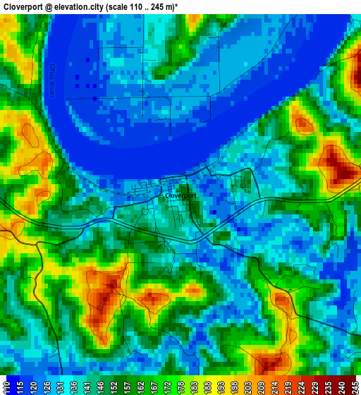
Below is the Elevation map of Cloverport, which displays elevation range with different colors. Scale of the first map is from 110 to 245 m (361 to 804 ft) with average elevation of 147.2 meters (=483 ft) [note 1]
These maps also provides idea of topography and contour of this city, they are displayed at different zoom levels. More info about maps, scale and edge coordinates you can find below images.
| \ | Map #1 | Topo.Map |
| Scale [m] | 110..245 m | × |
| Scale [ft] | 361..804 ft | × |
| Average | 147.2 m = 483 ft | × |
| Width | 7.72 km = 4.8 mi | 247 km = 153.5 mi |
| Height | 7.72 km = 4.8 mi | 247 km = 153.5 mi |
| ↑Max Latitude | 37.86809° | 38.93566° |
| Latitude at center | 37.83339° | 37.83339° |
| ↓Min Latitude | 37.798674° | 36.71441° |
| ← Min Longitude | -86.676705° | -88.03901° |
| Longitude center | -86.63276° | -86.63276° |
| →Max Longitude | -86.588815° | -85.22651° |
Nearby cities:
Cities around Cloverport sort by population:
• Owensboro elevation 125 m
42.7 km,  261°
261°
• Tell City 126 m
17.7 km,  317°
317°
• Knottsville 170 m
24.8 km,  253°
253°
• Brandenburg 171 m
44.6 km,  65°
65°
• Santa Claus 145 m
40.3 km, 322°
• Hardinsburg 216 m
16.3 km,  111°
111°
• Rockport 133 m
37 km,  278°
278°
• Lewisport 120 m
26.3 km,  295°
295°
• Cannelton 123 m
13.1 km,  311°
311°
• Irvington 192 m
31.1 km,  80°
80°
• Masonville 129 m
39.5 km,  243°
243°
• Hawesville 163 m
13 km, 304°
Multilingual:
 En español:
Cloverport elevación 154 m.
 En France:
Cloverport élévation 154 m.
 Auf Deutsch:
Cloverport höhe über dem Meeresspiegel ist 154 m.

Sources and notes:
- [note 1] Map square and city borders are not equal. Map elevation data is calculated only from area inside that square.
- [src 1] Elevation data from geonames database provided with same terms of usage.
- [src 2] The elevation map of Cloverport is generated using elevation data from NASA's 3 arcsec (90m) resolution SRTM data.
- [src 3] Base (background) map © OpenStreetMap contributors tiles are generated by Geofabrik and OpenTopoMap.
Copyright & License:
This Cloverport Elevation Map is licensed under CC BY-SA. You may reuse any part from this page, if you give a proper credit by linking to this URL:
 More info on terms of use page.