Hardinsburg elevation
Hardinsburg (Kentucky, Breckinridge County), United States elevation is 216 meters and Hardinsburg elevation in feet is 709 ft above sea level [src 1]. Hardinsburg is a seat of a second-order administrative division (feature code) with elevation that is 63 meters (207 ft) smaller than average city elevation in United States.
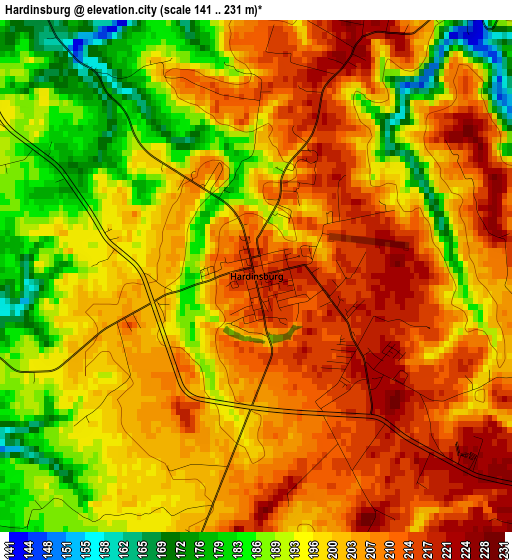
Below is the Elevation map of Hardinsburg, which displays elevation range with different colors. Scale of the first map is from 141 to 231 m (463 to 758 ft) with average elevation of 200.1 meters (=656 ft) [note 1]
These maps also provides idea of topography and contour of this city, they are displayed at different zoom levels. More info about maps, scale and edge coordinates you can find below images.
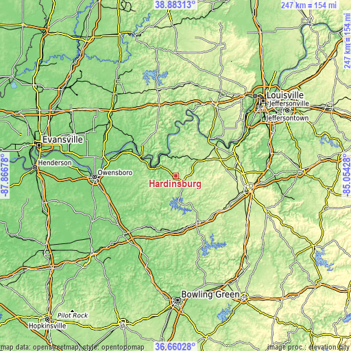
| \ | Map #1 | Topo.Map |
| Scale [m] | 141..231 m | × |
| Scale [ft] | 463..758 ft | × |
| Average | 200.1 m = 656 ft | × |
| Width | 7.72 km = 4.8 mi | 247.2 km = 153.6 mi |
| Height | 7.72 km = 4.8 mi | 247.2 km = 153.6 mi |
| ↑Max Latitude | 37.814785° | 38.88313° |
| Latitude at center | 37.78006° | 37.78006° |
| ↓Min Latitude | 37.745319° | 36.66028° |
| ← Min Longitude | -86.504475° | -87.86678° |
| Longitude center | -86.46053° | -86.46053° |
| →Max Longitude | -86.416585° | -85.05428° |
Nearby cities:
Cities around Hardinsburg sort by population:
• Fort Knox elevation 224 m
45.3 km,  74°
74°
• Tell City 126 m
33 km,  305°
305°
• Leitchfield 229 m
36.4 km,  156°
156°
• Knottsville 170 m
39 km,  268°
268°
• Vine Grove 210 m
42.2 km,  85°
85°
• Brandenburg 171 m
35.3 km,  46°
46°
• Doe Valley 188 m
36 km,  56°
56°
• Lewisport 120 m
42.5 km,  294°
294°
• Cannelton 123 m
28.9 km,  300°
300°
• Irvington 192 m
19.1 km, 54°
• Cloverport 154 m
16.3 km, 291°
• Hawesville 163 m
29.1 km, 297°
Multilingual:
 En español:
Hardinsburg elevación 216 m.
 En France:
Hardinsburg élévation 216 m.
 Auf Deutsch:
Hardinsburg höhe über dem Meeresspiegel ist 216 m.

Sources and notes:
- [note 1] Map square and city borders are not equal. Map elevation data is calculated only from area inside that square.
- [src 1] Elevation data from geonames database provided with same terms of usage.
- [src 2] The elevation map of Hardinsburg is generated using elevation data from NASA's 3 arcsec (90m) resolution SRTM data.
- [src 3] Base (background) map © OpenStreetMap contributors tiles are generated by Geofabrik and OpenTopoMap.
Copyright & License:
This Hardinsburg Elevation Map is licensed under CC BY-SA. You may reuse any part from this page, if you give a proper credit by linking to this URL:
 More info on terms of use page.