Cave City elevation
Cave City (Kentucky, Barren County), United States elevation is 195 meters and Cave City elevation in feet is 640 ft above sea level [src 1]. Cave City is a populated place (feature code) with elevation that is 84 meters (276 ft) smaller than average city elevation in United States.
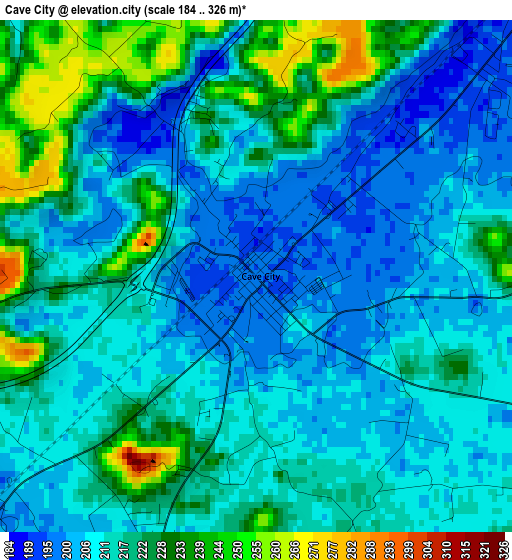
Below is the Elevation map of Cave City, which displays elevation range with different colors. Scale of the first map is from 184 to 326 m (604 to 1070 ft) with average elevation of 214.5 meters (=704 ft) [note 1]
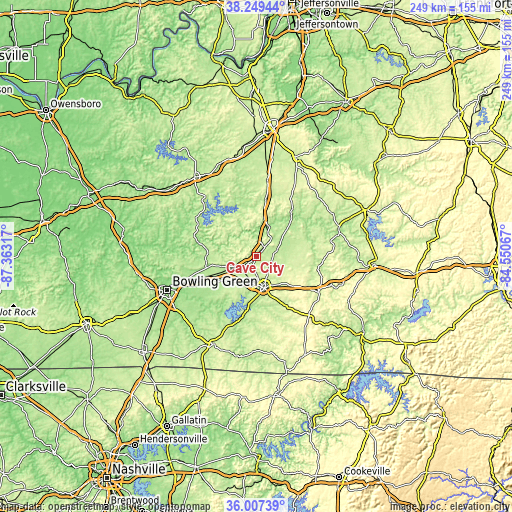
These maps also provides idea of topography and contour of this city, they are displayed at different zoom levels. More info about maps, scale and edge coordinates you can find below images.
| \ | Map #1 | Topo.Map |
| Scale [m] | 184..326 m | × |
| Scale [ft] | 604..1070 ft | × |
| Average | 214.5 m = 704 ft | × |
| Width | 7.79 km = 4.8 mi | 249.3 km = 154.9 mi |
| Height | 7.79 km = 4.8 mi | 249.3 km = 154.9 mi |
| ↑Max Latitude | 37.171745° | 38.24944° |
| Latitude at center | 37.13672° | 37.13672° |
| ↓Min Latitude | 37.101679° | 36.00739° |
| ← Min Longitude | -86.000865° | -87.36317° |
| Longitude center | -85.95692° | -85.95692° |
| →Max Longitude | -85.912975° | -84.55067° |
Nearby cities:
Cities around Cave City sort by population:
• Bowling Green elevation 163 m
46.1 km,  249°
249°
• Glasgow 228 m
16.2 km,  165°
165°
• Leitchfield 229 m
48.4 km,  322°
322°
• Scottsville 231 m
47.4 km,  205°
205°
• Hodgenville 222 m
52.3 km,  21°
21°
• Horse Cave 194 m
6.5 km,  42°
42°
• Tompkinsville 282 m
53.8 km,  153°
153°
• Greensburg 183 m
42.9 km,  71°
71°
• Munfordville 191 m
16.2 km, 21°
• Edmonton 255 m
35.2 km,  119°
119°
• Plano 186 m
49.9 km,  235°
235°
• Brownsville 169 m
28.2 km,  282°
282°
Multilingual:
 En español:
Cave City elevación 195 m.
 En France:
Cave City élévation 195 m.
 Auf Deutsch:
Cave City höhe über dem Meeresspiegel ist 195 m.

Sources and notes:
- [note 1] Map square and city borders are not equal. Map elevation data is calculated only from area inside that square.
- [src 1] Elevation data from geonames database provided with same terms of usage.
- [src 2] The elevation map of Cave City is generated using elevation data from NASA's 3 arcsec (90m) resolution SRTM data.
- [src 3] Base (background) map © OpenStreetMap contributors tiles are generated by Geofabrik and OpenTopoMap.
Copyright & License:
This Cave City Elevation Map is licensed under CC BY-SA. You may reuse any part from this page, if you give a proper credit by linking to this URL:
 More info on terms of use page.