Mount Ida elevation
Mount Ida (Arkansas, Montgomery County), United States elevation is 206 meters and Mount Ida elevation in feet is 676 ft above sea level [src 1]. Mount Ida is a seat of a second-order administrative division (feature code) with elevation that is 73 meters (240 ft) smaller than average city elevation in United States.
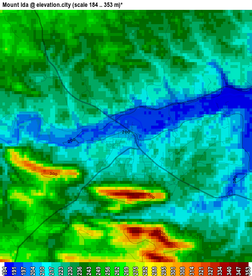
Below is the Elevation map of Mount Ida, which displays elevation range with different colors. Scale of the first map is from 184 to 353 m (604 to 1158 ft) with average elevation of 233.3 meters (=765 ft) [note 1]
These maps also provides idea of topography and contour of this city, they are displayed at different zoom levels. More info about maps, scale and edge coordinates you can find below images.
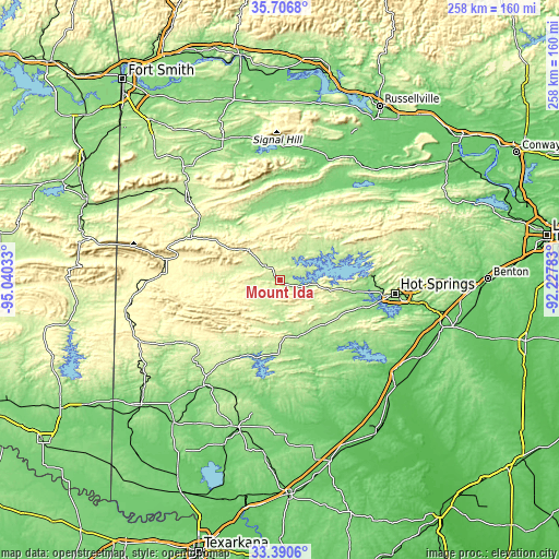
| \ | Map #1 | Topo.Map |
| Scale [m] | 184..353 m | × |
| Scale [ft] | 604..1158 ft | × |
| Average | 233.3 m = 765 ft | × |
| Width | 8.05 km = 5 mi | 257.5 km = 160 mi |
| Height | 8.05 km = 5 mi | 257.5 km = 160 mi |
| ↑Max Latitude | 34.592944° | 35.7068° |
| Latitude at center | 34.55676° | 34.55676° |
| ↓Min Latitude | 34.52056° | 33.3906° |
| ← Min Longitude | -93.678025° | -95.04033° |
| Longitude center | -93.63408° | -93.63408° |
| →Max Longitude | -93.590135° | -92.22783° |
Nearby cities:
Cities around Mount Ida sort by population:
• Hot Springs elevation 184 m
53.4 km,  96°
96°
• Hot Springs National Park 229 m
52.3 km,  93°
93°
• Hot Springs Village 254 m
59.5 km,  77°
77°
• Mena 364 m
55.5 km,  273°
273°
• Piney 134 m
46.9 km, 97°
• Rockwell 140 m
47 km, 102°
• Waldron 205 m
56.4 km,  312°
312°
• Danville 109 m
59.5 km,  21°
21°
• Glenwood 175 m
26.7 km,  163°
163°
• Lake Hamilton 139 m
51.5 km,  106°
106°
• Murfreesboro 115 m
55.2 km,  185°
185°
• Dierks 137 m
60 km,  215°
215°
Multilingual:
 En español:
Mount Ida elevación 206 m.
 En France:
Mount Ida élévation 206 m.
 Auf Deutsch:
Mount Ida höhe über dem Meeresspiegel ist 206 m.

Sources and notes:
- [note 1] Map square and city borders are not equal. Map elevation data is calculated only from area inside that square.
- [src 1] Elevation data from geonames database provided with same terms of usage.
- [src 2] The elevation map of Mount Ida is generated using elevation data from NASA's 3 arcsec (90m) resolution SRTM data.
- [src 3] Base (background) map © OpenStreetMap contributors tiles are generated by Geofabrik and OpenTopoMap.
Copyright & License:
This Mount Ida Elevation Map is licensed under CC BY-SA. You may reuse any part from this page, if you give a proper credit by linking to this URL:
 More info on terms of use page.