Waldron elevation
Waldron (Arkansas, Scott County), United States elevation is 205 meters and Waldron elevation in feet is 673 ft above sea level [src 1]. Waldron is a seat of a second-order administrative division (feature code) with elevation that is 74 meters (243 ft) smaller than average city elevation in United States.
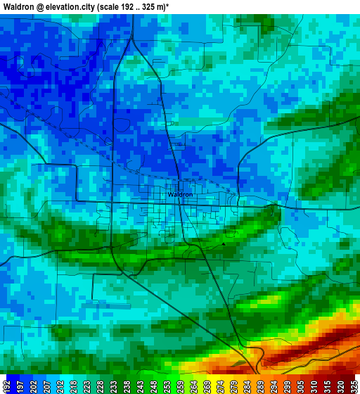
Below is the Elevation map of Waldron, which displays elevation range with different colors. Scale of the first map is from 192 to 325 m (630 to 1066 ft) with average elevation of 221.4 meters (=726 ft) [note 1]
These maps also provides idea of topography and contour of this city, they are displayed at different zoom levels. More info about maps, scale and edge coordinates you can find below images.
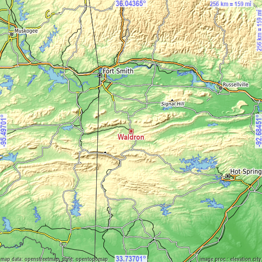
| \ | Map #1 | Topo.Map |
| Scale [m] | 192..325 m | × |
| Scale [ft] | 630..1066 ft | × |
| Average | 221.4 m = 726 ft | × |
| Width | 8.02 km = 5 mi | 256.5 km = 159.4 mi |
| Height | 8.02 km = 5 mi | 256.5 km = 159.4 mi |
| ↑Max Latitude | 34.934465° | 36.04365° |
| Latitude at center | 34.89843° | 34.89843° |
| ↓Min Latitude | 34.86238° | 33.73701° |
| ← Min Longitude | -94.134705° | -95.49701° |
| Longitude center | -94.09076° | -94.09076° |
| →Max Longitude | -94.046815° | -92.68451° |
Nearby cities:
Cities around Waldron sort by population:
• Greenwood elevation 164 m
38.3 km,  336°
336°
• Poteau 153 m
51.5 km,  289°
289°
• Mena 364 m
37.3 km,  201°
201°
• Barling 152 m
51.2 km, 338°
• Pocola 152 m
51.1 km,  316°
316°
• Booneville 157 m
31 km,  29°
29°
• Paris 128 m
54.7 km,  36°
36°
• Heavener 174 m
46.5 km,  268°
268°
• Charleston 165 m
44.6 km,  6°
6°
• Lavaca 135 m
49.3 km,  351°
351°
• Mansfield 191 m
23.2 km, 320°
• Mount Ida 206 m
56.4 km,  132°
132°
Multilingual:
 En español:
Waldron elevación 205 m.
 En France:
Waldron élévation 205 m.


Sources and notes:
- [note 1] Map square and city borders are not equal. Map elevation data is calculated only from area inside that square.
- [src 1] Elevation data from geonames database provided with same terms of usage.
- [src 2] The elevation map of Waldron is generated using elevation data from NASA's 3 arcsec (90m) resolution SRTM data.
- [src 3] Base (background) map © OpenStreetMap contributors tiles are generated by Geofabrik and OpenTopoMap.
Copyright & License:
This Waldron Elevation Map is licensed under CC BY-SA. You may reuse any part from this page, if you give a proper credit by linking to this URL:
 More info on terms of use page.