Booneville elevation
Booneville (Arkansas, Logan County), United States elevation is 157 meters and Booneville elevation in feet is 515 ft above sea level [src 1]. Booneville is a populated place (feature code) with elevation that is 122 meters (400 ft) smaller than average city elevation in United States.
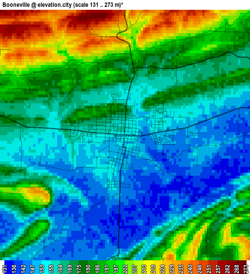
Below is the Elevation map of Booneville, which displays elevation range with different colors. Scale of the first map is from 131 to 273 m (430 to 896 ft) with average elevation of 173.1 meters (=568 ft) [note 1]
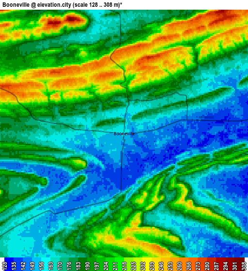
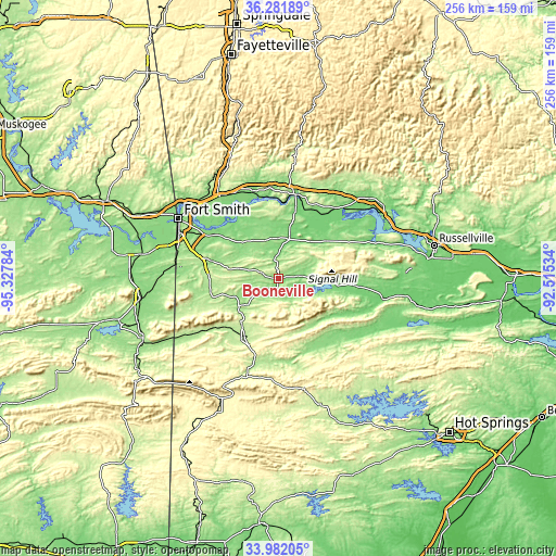
These maps also provides idea of topography and contour of this city, they are displayed at different zoom levels. More info about maps, scale and edge coordinates you can find below images.
| \ | Map #1 | Map #2 | Topo.Map |
| Scale [m] | 131..273 m | 128..308 m | × |
| Scale [ft] | 430..896 ft | 420..1010 ft | × |
| Average | 173.1 m = 568 ft | 185.3 m = 608 ft | × |
| Width | 7.99 km = 5 mi | 15.98 km = 9.9 mi | 255.7 km = 158.9 mi |
| Height | 7.99 km = 5 mi | 15.98 km = 9.9 mi | 255.7 km = 158.9 mi |
| ↑Max Latitude | 35.176018° | 35.211931° | 36.28189° |
| Latitude at center | 35.14009° | 35.14009° | 35.14009° |
| ↓Min Latitude | 35.104146° | 35.068186° | 33.98205° |
| ← Min Longitude | -93.965535° | -94.009481° | -95.32784° |
| Longitude center | -93.92159° | -93.92159° | -93.92159° |
| →Max Longitude | -93.877645° | -93.833699° | -92.51534° |
Nearby cities:
Cities around Booneville sort by population:
• Greenwood elevation 164 m
31.5 km,  285°
285°
• Alma 133 m
46.4 km,  324°
324°
• Barling 152 m
40.2 km,  300°
300°
• Ozark 126 m
39.5 km,  12°
12°
• Paris 128 m
24.3 km,  45°
45°
• Waldron 205 m
31 km,  209°
209°
• Charleston 165 m
20.3 km,  329°
329°
• Lavaca 135 m
31.6 km,  313°
313°
• Danville 109 m
49 km,  101°
101°
• Mulberry 127 m
41.8 km,  343°
343°
• Mansfield 191 m
31.4 km,  253°
253°
• Coal Hill 147 m
40 km,  34°
34°
Multilingual:
 En español:
Booneville elevación 157 m.
 En France:
Booneville élévation 157 m.
 Auf Deutsch:
Booneville höhe über dem Meeresspiegel ist 157 m.

Sources and notes:
- [note 1] Map square and city borders are not equal. Map elevation data is calculated only from area inside that square.
- [src 1] Elevation data from geonames database provided with same terms of usage.
- [src 2] The elevation map of Booneville is generated using elevation data from NASA's 3 arcsec (90m) resolution SRTM data.
- [src 3] Base (background) map © OpenStreetMap contributors tiles are generated by Geofabrik and OpenTopoMap.
Copyright & License:
This Booneville Elevation Map is licensed under CC BY-SA. You may reuse any part from this page, if you give a proper credit by linking to this URL:
 More info on terms of use page.