Alma elevation
Alma (Arkansas, Crawford County), United States elevation is 133 meters and Alma elevation in feet is 436 ft above sea level [src 1]. Alma is a populated place (feature code) with elevation that is 146 meters (479 ft) smaller than average city elevation in United States.
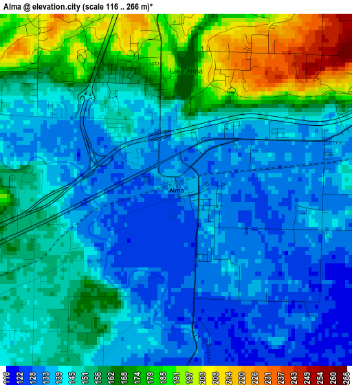
Below is the Elevation map of Alma, which displays elevation range with different colors. Scale of the first map is from 116 to 266 m (381 to 873 ft) with average elevation of 151.1 meters (=496 ft) [note 1]
These maps also provides idea of topography and contour of this city, they are displayed at different zoom levels. More info about maps, scale and edge coordinates you can find below images.
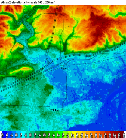
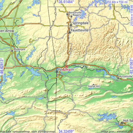
| \ | Map #1 | Map #2 | Topo.Map |
| Scale [m] | 116..266 m | 108..280 m | × |
| Scale [ft] | 381..873 ft | 354..919 ft | × |
| Average | 151.1 m = 496 ft | 166.1 m = 545 ft | × |
| Width | 7.96 km = 4.9 mi | 15.92 km = 9.9 mi | 254.7 km = 158.3 mi |
| Height | 7.96 km = 4.9 mi | 15.92 km = 9.9 mi | 254.7 km = 158.3 mi |
| ↑Max Latitude | 35.513648° | 35.549411° | 36.61484° |
| Latitude at center | 35.47787° | 35.47787° | 35.47787° |
| ↓Min Latitude | 35.442076° | 35.406265° | 34.32459° |
| ← Min Longitude | -94.265825° | -94.309771° | -95.62813° |
| Longitude center | -94.22188° | -94.22188° | -94.22188° |
| →Max Longitude | -94.177935° | -94.133989° | -92.81563° |
Nearby cities:
Cities around Alma sort by population:
• Fort Smith elevation 135 m
19 km,  237°
237°
• Van Buren 127 m
12.3 km,  248°
248°
• Greenwood 164 m
29.3 km,  186°
186°
• Barling 152 m
18.4 km,  203°
203°
• Ozark 126 m
35.7 km,  88°
88°
• Roland 147 m
27.3 km,  256°
256°
• Muldrow 160 m
35.1 km, 256°
• Charleston 165 m
26.2 km,  140°
140°
• Lavaca 135 m
16.4 km,  164°
164°
• Arkoma 160 m
23.6 km,  234°
234°
• Mulberry 127 m
15.6 km,  80°
80°
• Cedarville 244 m
16.6 km,  307°
307°
Multilingual:
 En español:
Alma elevación 133 m.
 En France:
Alma élévation 133 m.


Sources and notes:
- [note 1] Map square and city borders are not equal. Map elevation data is calculated only from area inside that square.
- [src 1] Elevation data from geonames database provided with same terms of usage.
- [src 2] The elevation map of Alma is generated using elevation data from NASA's 3 arcsec (90m) resolution SRTM data.
- [src 3] Base (background) map © OpenStreetMap contributors tiles are generated by Geofabrik and OpenTopoMap.
Copyright & License:
This Alma Elevation Map is licensed under CC BY-SA. You may reuse any part from this page, if you give a proper credit by linking to this URL:
 More info on terms of use page.