Roland elevation
Roland (Oklahoma, Sequoyah County), United States elevation is 147 meters and Roland elevation in feet is 482 ft above sea level [src 1]. Roland is a populated place (feature code) with elevation that is 132 meters (433 ft) smaller than average city elevation in United States.
Below is the Elevation map of Roland, which displays elevation range with different colors. Scale of the first map is from 123 to 307 m (404 to 1007 ft) with average elevation of 173.9 meters (=571 ft) [note 1]
These maps also provides idea of topography and contour of this city, they are displayed at different zoom levels. More info about maps, scale and edge coordinates you can find below images.
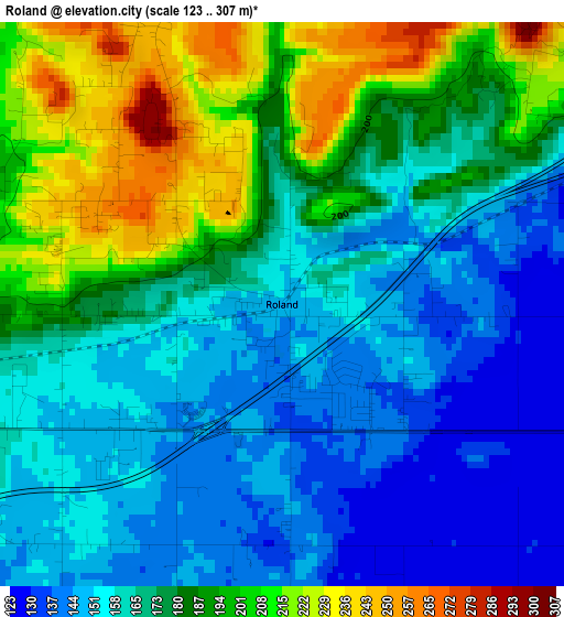
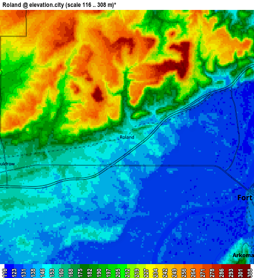
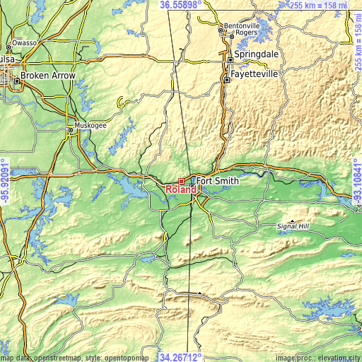
| \ | Map #1 | Map #2 | Topo.Map |
| Scale [m] | 123..307 m | 116..308 m | × |
| Scale [ft] | 404..1007 ft | 381..1010 ft | × |
| Average | 173.9 m = 571 ft | 176.7 m = 580 ft | × |
| Width | 7.96 km = 4.9 mi | 15.93 km = 9.9 mi | 254.8 km = 158.3 mi |
| Height | 7.96 km = 4.9 mi | 15.93 km = 9.9 mi | 254.8 km = 158.3 mi |
| ↑Max Latitude | 35.457004° | 35.492791° | 36.55898° |
| Latitude at center | 35.4212° | 35.4212° | 35.4212° |
| ↓Min Latitude | 35.38538° | 35.349545° | 34.26712° |
| ← Min Longitude | -94.558605° | -94.602551° | -95.92091° |
| Longitude center | -94.51466° | -94.51466° | -94.51466° |
| →Max Longitude | -94.470715° | -94.426769° | -93.10841° |
Nearby cities:
Cities around Roland sort by population:
• Fort Smith elevation 135 m
11.2 km,  110°
110°
• Van Buren 127 m
15.2 km,  83°
83°
• Sallisaw 165 m
25.1 km,  279°
279°
• Alma 133 m
27.3 km, 76°
• Barling 152 m
22 km,  118°
118°
• Pocola 152 m
21.4 km,  171°
171°
• Muldrow 160 m
7.8 km,  257°
257°
• Lavaca 135 m
32.4 km, 106°
• Spiro 155 m
22.2 km,  205°
205°
• Arkoma 160 m
10.4 km,  135°
135°
• Panama 141 m
31.7 km, 206°
• Cedarville 244 m
21.3 km,  38°
38°
Multilingual:
 En español:
Roland elevación 147 m.
 En France:
Roland élévation 147 m.


Sources and notes:
- [note 1] Map square and city borders are not equal. Map elevation data is calculated only from area inside that square.
- [src 1] Elevation data from geonames database provided with same terms of usage.
- [src 2] The elevation map of Roland is generated using elevation data from NASA's 3 arcsec (90m) resolution SRTM data.
- [src 3] Base (background) map © OpenStreetMap contributors tiles are generated by Geofabrik and OpenTopoMap.
Copyright & License:
This Roland Elevation Map is licensed under CC BY-SA. You may reuse any part from this page, if you give a proper credit by linking to this URL:
 More info on terms of use page.