Glenwood elevation
Glenwood (Arkansas, Pike County), United States elevation is 175 meters and Glenwood elevation in feet is 574 ft above sea level [src 1]. Glenwood is a populated place (feature code) with elevation that is 104 meters (341 ft) smaller than average city elevation in United States.
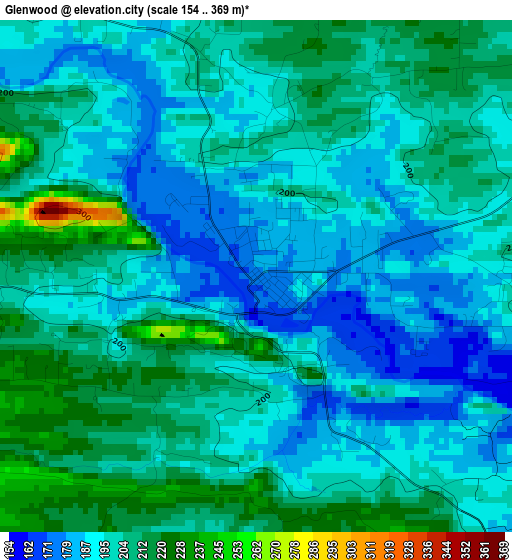
Below is the Elevation map of Glenwood, which displays elevation range with different colors. Scale of the first map is from 154 to 369 m (505 to 1211 ft) with average elevation of 199.3 meters (=654 ft) [note 1]
These maps also provides idea of topography and contour of this city, they are displayed at different zoom levels. More info about maps, scale and edge coordinates you can find below images.
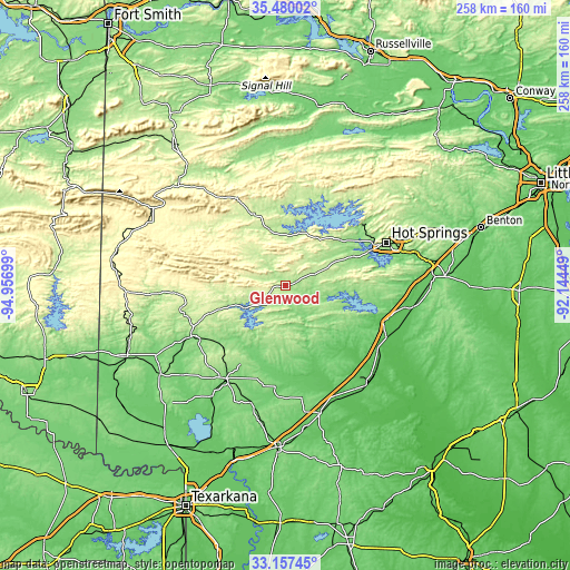
| \ | Map #1 | Topo.Map |
| Scale [m] | 154..369 m | × |
| Scale [ft] | 505..1211 ft | × |
| Average | 199.3 m = 654 ft | × |
| Width | 8.07 km = 5 mi | 258.2 km = 160.4 mi |
| Height | 8.07 km = 5 mi | 258.2 km = 160.4 mi |
| ↑Max Latitude | 34.363054° | 35.48002° |
| Latitude at center | 34.32677° | 34.32677° |
| ↓Min Latitude | 34.290471° | 33.15745° |
| ← Min Longitude | -93.594685° | -94.95699° |
| Longitude center | -93.55074° | -93.55074° |
| →Max Longitude | -93.506795° | -92.14449° |
Nearby cities:
Cities around Glenwood sort by population:
• Hot Springs elevation 184 m
49.5 km,  66°
66°
• Hot Springs National Park 229 m
50.1 km,  62°
62°
• Arkadelphia 81 m
51.1 km,  116°
116°
• Piney 134 m
43.6 km, 63°
• Nashville 120 m
50.4 km,  212°
212°
• Rockwell 140 m
41.2 km, 68°
• Prescott 106 m
60.3 km,  164°
164°
• Gurdon 66 m
58 km,  141°
141°
• Lake Hamilton 139 m
43.2 km,  75°
75°
• Murfreesboro 115 m
32.1 km,  203°
203°
• Dierks 137 m
48.6 km,  241°
241°
• Mount Ida 206 m
26.7 km,  343°
343°
Multilingual:
 En español:
Glenwood elevación 175 m.
 En France:
Glenwood élévation 175 m.
 Auf Deutsch:
Glenwood höhe über dem Meeresspiegel ist 175 m.

Sources and notes:
- [note 1] Map square and city borders are not equal. Map elevation data is calculated only from area inside that square.
- [src 1] Elevation data from geonames database provided with same terms of usage.
- [src 2] The elevation map of Glenwood is generated using elevation data from NASA's 3 arcsec (90m) resolution SRTM data.
- [src 3] Base (background) map © OpenStreetMap contributors tiles are generated by Geofabrik and OpenTopoMap.
Copyright & License:
This Glenwood Elevation Map is licensed under CC BY-SA. You may reuse any part from this page, if you give a proper credit by linking to this URL:
 More info on terms of use page.