Hot Springs elevation
Hot Springs (Arkansas, Garland County), United States elevation is 184 meters and Hot Springs elevation in feet is 604 ft above sea level [src 1]. Hot Springs is a seat of a second-order administrative division (feature code) with elevation that is 95 meters (312 ft) smaller than average city elevation in United States.
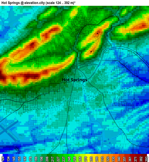
Below is the Elevation map of Hot Springs, which displays elevation range with different colors. Scale of the first map is from 124 to 392 m (407 to 1286 ft) with average elevation of 199.1 meters (=653 ft) [note 1]
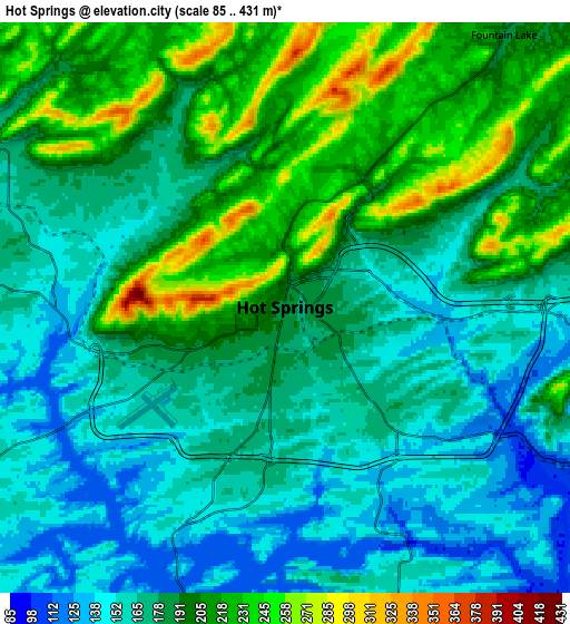
These maps also provides idea of topography and contour of this city, they are displayed at different zoom levels. More info about maps, scale and edge coordinates you can find below images.
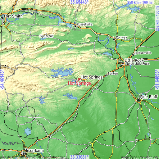
| \ | Map #1 | Map #2 | Topo.Map |
| Scale [m] | 124..392 m | 85..431 m | × |
| Scale [ft] | 407..1286 ft | 279..1414 ft | × |
| Average | 199.1 m = 653 ft | 185.2 m = 608 ft | × |
| Width | 8.05 km = 5 mi | 16.11 km = 10 mi | 257.7 km = 160.1 mi |
| Height | 8.05 km = 5 mi | 16.11 km = 10 mi | 257.7 km = 160.1 mi |
| ↑Max Latitude | 34.539907° | 34.576098° | 35.65448° |
| Latitude at center | 34.5037° | 34.5037° | 34.5037° |
| ↓Min Latitude | 34.467477° | 34.431239° | 33.33681° |
| ← Min Longitude | -93.099125° | -93.143071° | -94.46143° |
| Longitude center | -93.05518° | -93.05518° | -93.05518° |
| →Max Longitude | -93.011235° | -92.967289° | -91.64893° |
Nearby cities:
Cities around Hot Springs sort by population:
• Hot Springs National Park elevation 229 m
3.2 km,  345°
345°
• Benton 131 m
43.4 km,  81°
81°
• Bryant 127 m
52.9 km, 78°
• Hot Springs Village 254 m
19.4 km,  15°
15°
• Malvern 102 m
27.2 km,  125°
125°
• Arkadelphia 81 m
42.6 km,  179°
179°
• Piney 134 m
6.5 km,  269°
269°
• Haskell 99 m
38.4 km,  90°
90°
• Rockwell 140 m
8.4 km,  238°
238°
• Salem 150 m
47.6 km,  72°
72°
• Glenwood 175 m
49.5 km,  246°
246°
• Lake Hamilton 139 m
9.5 km,  202°
202°
Multilingual:
 En español:
Hot Springs elevación 184 m.
 En France:
Hot Springs élévation 184 m.
 Auf Deutsch:
Hot Springs höhe über dem Meeresspiegel ist 184 m.

Sources and notes:
- [note 1] Map square and city borders are not equal. Map elevation data is calculated only from area inside that square.
- [src 1] Elevation data from geonames database provided with same terms of usage.
- [src 2] The elevation map of Hot Springs is generated using elevation data from NASA's 3 arcsec (90m) resolution SRTM data.
- [src 3] Base (background) map © OpenStreetMap contributors tiles are generated by Geofabrik and OpenTopoMap.
Copyright & License:
This Hot Springs Elevation Map is licensed under CC BY-SA. You may reuse any part from this page, if you give a proper credit by linking to this URL:
 More info on terms of use page.