Dierks elevation
Dierks (Arkansas, Howard County), United States elevation is 137 meters and Dierks elevation in feet is 449 ft above sea level [src 1]. Dierks is a populated place (feature code) with elevation that is 142 meters (466 ft) smaller than average city elevation in United States.
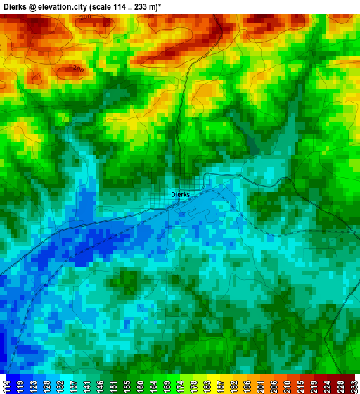
Below is the Elevation map of Dierks, which displays elevation range with different colors. Scale of the first map is from 114 to 233 m (374 to 764 ft) with average elevation of 156.4 meters (=513 ft) [note 1]
These maps also provides idea of topography and contour of this city, they are displayed at different zoom levels. More info about maps, scale and edge coordinates you can find below images.
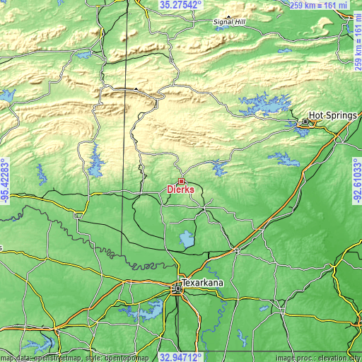
| \ | Map #1 | Topo.Map |
| Scale [m] | 114..233 m | × |
| Scale [ft] | 374..764 ft | × |
| Average | 156.4 m = 513 ft | × |
| Width | 8.09 km = 5 mi | 258.9 km = 160.9 mi |
| Height | 8.09 km = 5 mi | 258.9 km = 160.9 mi |
| ↑Max Latitude | 34.155653° | 35.27542° |
| Latitude at center | 34.11928° | 34.11928° |
| ↓Min Latitude | 34.082891° | 32.94712° |
| ← Min Longitude | -94.060525° | -95.42283° |
| Longitude center | -94.01658° | -94.01658° |
| →Max Longitude | -93.972635° | -92.61033° |
Nearby cities:
Cities around Dierks sort by population:
• Hope elevation 112 m
63.8 km,  142°
142°
• De Queen 131 m
31.2 km,  253°
253°
• Mena 364 m
55.8 km,  338°
338°
• Ashdown 103 m
50.6 km,  192°
192°
• Nashville 120 m
24.8 km, 141°
• Broken Bow 146 m
67.3 km,  261°
261°
• Prescott 106 m
68.4 km,  120°
120°
• Glenwood 175 m
48.6 km,  61°
61°
• Murfreesboro 115 m
30.7 km,  101°
101°
• Mineral Springs 107 m
28.8 km,  160°
160°
• Horatio 127 m
37.3 km,  237°
237°
• Mount Ida 206 m
60 km,  35°
35°
Multilingual:
 En español:
Dierks elevación 137 m.
 En France:
Dierks élévation 137 m.


Sources and notes:
- [note 1] Map square and city borders are not equal. Map elevation data is calculated only from area inside that square.
- [src 1] Elevation data from geonames database provided with same terms of usage.
- [src 2] The elevation map of Dierks is generated using elevation data from NASA's 3 arcsec (90m) resolution SRTM data.
- [src 3] Base (background) map © OpenStreetMap contributors tiles are generated by Geofabrik and OpenTopoMap.
Copyright & License:
This Dierks Elevation Map is licensed under CC BY-SA. You may reuse any part from this page, if you give a proper credit by linking to this URL:
 More info on terms of use page.