Ashdown elevation
Ashdown (Arkansas, Little River County), United States elevation is 103 meters and Ashdown elevation in feet is 338 ft above sea level [src 1]. Ashdown is a seat of a second-order administrative division (feature code) with elevation that is 176 meters (577 ft) smaller than average city elevation in United States.
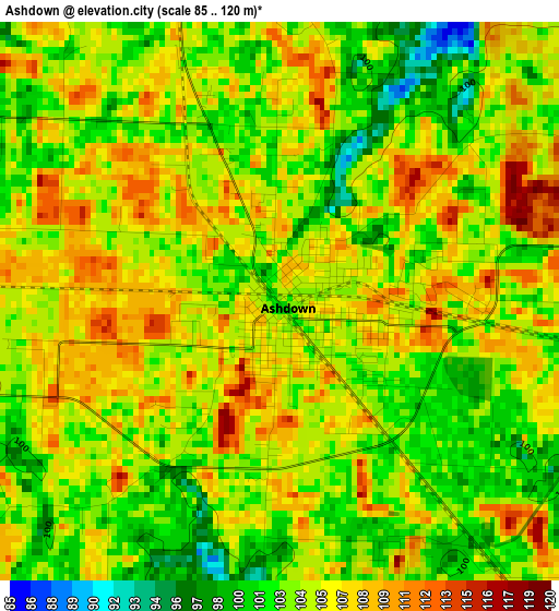
Below is the Elevation map of Ashdown, which displays elevation range with different colors. Scale of the first map is from 85 to 120 m (279 to 394 ft) with average elevation of 104.5 meters (=343 ft) [note 1]
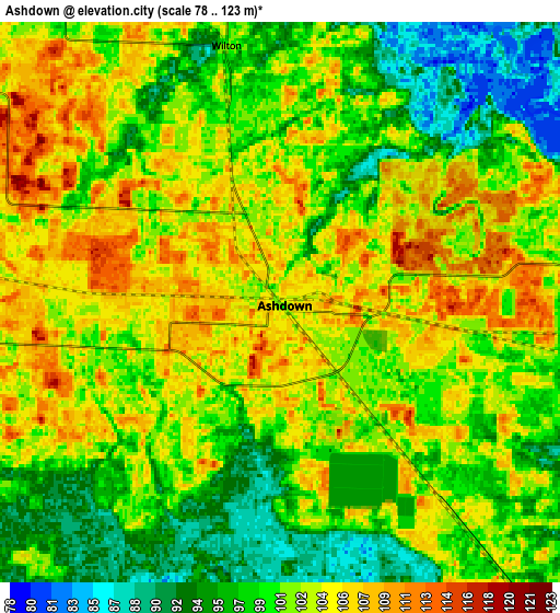
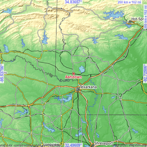
These maps also provides idea of topography and contour of this city, they are displayed at different zoom levels. More info about maps, scale and edge coordinates you can find below images.
| \ | Map #1 | Map #2 | Topo.Map |
| Scale [m] | 85..120 m | 78..123 m | × |
| Scale [ft] | 279..394 ft | 256..404 ft | × |
| Average | 104.5 m = 343 ft | 101.1 m = 332 ft | × |
| Width | 8.13 km = 5.1 mi | 16.27 km = 10.1 mi | 260.2 km = 161.7 mi |
| Height | 8.13 km = 5.1 mi | 16.27 km = 10.1 mi | 260.2 km = 161.7 mi |
| ↑Max Latitude | 33.710854° | 33.747402° | 34.83657° |
| Latitude at center | 33.67429° | 33.67429° | 33.67429° |
| ↓Min Latitude | 33.637711° | 33.601116° | 32.49609° |
| ← Min Longitude | -94.175255° | -94.219201° | -95.53756° |
| Longitude center | -94.13131° | -94.13131° | -94.13131° |
| →Max Longitude | -94.087365° | -94.043419° | -92.72506° |
Nearby cities:
Cities around Ashdown sort by population:
• Texarkana elevation 95 m
28.8 km,  164°
164°
• Texarkana 118 m
27.3 km, 161°
• Wake Village 106 m
27.6 km,  175°
175°
• New Boston 111 m
35.5 km,  227°
227°
• Nashville 120 m
40 km,  41°
41°
• Nash 112 m
25.8 km, 179°
• Hooks 116 m
27.3 km,  212°
212°
• Mineral Springs 107 m
30 km, 41°
• Maud 93 m
42.7 km, 207°
• Redwater 94 m
37 km,  197°
197°
• Horatio 127 m
36 km,  324°
324°
• Red Lick 113 m
23.6 km,  188°
188°
Multilingual:
 En español:
Ashdown elevación 103 m.
 En France:
Ashdown élévation 103 m.


Sources and notes:
- [note 1] Map square and city borders are not equal. Map elevation data is calculated only from area inside that square.
- [src 1] Elevation data from geonames database provided with same terms of usage.
- [src 2] The elevation map of Ashdown is generated using elevation data from NASA's 3 arcsec (90m) resolution SRTM data.
- [src 3] Base (background) map © OpenStreetMap contributors tiles are generated by Geofabrik and OpenTopoMap.
Copyright & License:
This Ashdown Elevation Map is licensed under CC BY-SA. You may reuse any part from this page, if you give a proper credit by linking to this URL:
 More info on terms of use page.