Murfreesboro elevation
Murfreesboro (Arkansas, Pike County), United States elevation is 115 meters and Murfreesboro elevation in feet is 377 ft above sea level [src 1]. Murfreesboro is a seat of a second-order administrative division (feature code) with elevation that is 164 meters (538 ft) smaller than average city elevation in United States.
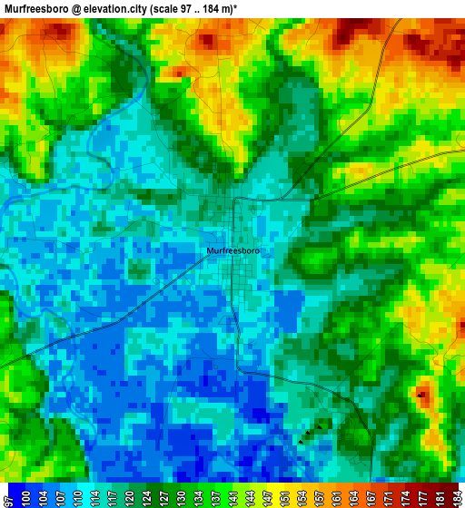
Below is the Elevation map of Murfreesboro, which displays elevation range with different colors. Scale of the first map is from 97 to 184 m (318 to 604 ft) with average elevation of 126.1 meters (=414 ft) [note 1]
These maps also provides idea of topography and contour of this city, they are displayed at different zoom levels. More info about maps, scale and edge coordinates you can find below images.
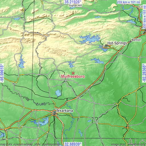
| \ | Map #1 | Topo.Map |
| Scale [m] | 97..184 m | × |
| Scale [ft] | 318..604 ft | × |
| Average | 126.1 m = 414 ft | × |
| Width | 8.1 km = 5 mi | 259.1 km = 161 mi |
| Height | 8.1 km = 5 mi | 259.1 km = 161 mi |
| ↑Max Latitude | 34.098728° | 35.21926° |
| Latitude at center | 34.06233° | 34.06233° |
| ↓Min Latitude | 34.025917° | 32.88939° |
| ← Min Longitude | -93.733845° | -95.09615° |
| Longitude center | -93.6899° | -93.6899° |
| →Max Longitude | -93.645955° | -92.28365° |
Nearby cities:
Cities around Murfreesboro sort by population:
• Arkadelphia elevation 81 m
58.9 km,  83°
83°
• Hope 112 m
44.9 km,  168°
168°
• De Queen 131 m
60.1 km,  267°
267°
• Ashdown 103 m
59.3 km,  223°
223°
• Nashville 120 m
19.4 km,  228°
228°
• Prescott 106 m
40.6 km,  135°
135°
• Gurdon 66 m
51.8 km,  107°
107°
• Glenwood 175 m
32.1 km,  23°
23°
• Mineral Springs 107 m
29.3 km, 224°
• Dierks 137 m
30.7 km,  281°
281°
• Horatio 127 m
63 km,  257°
257°
• Mount Ida 206 m
55.2 km,  5°
5°
Multilingual:
 En español:
Murfreesboro elevación 115 m.
 En France:
Murfreesboro élévation 115 m.
 Auf Deutsch:
Murfreesboro höhe über dem Meeresspiegel ist 115 m.

Sources and notes:
- [note 1] Map square and city borders are not equal. Map elevation data is calculated only from area inside that square.
- [src 1] Elevation data from geonames database provided with same terms of usage.
- [src 2] The elevation map of Murfreesboro is generated using elevation data from NASA's 3 arcsec (90m) resolution SRTM data.
- [src 3] Base (background) map © OpenStreetMap contributors tiles are generated by Geofabrik and OpenTopoMap.
Copyright & License:
This Murfreesboro Elevation Map is licensed under CC BY-SA. You may reuse any part from this page, if you give a proper credit by linking to this URL:
 More info on terms of use page.