Uniontown elevation
Uniontown (Alabama, Perry County), United States elevation is 92 meters and Uniontown elevation in feet is 302 ft above sea level [src 1]. Uniontown is a populated place (feature code) with elevation that is 187 meters (614 ft) smaller than average city elevation in United States.
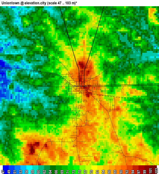
Below is the Elevation map of Uniontown, which displays elevation range with different colors. Scale of the first map is from 47 to 103 m (154 to 338 ft) with average elevation of 72.6 meters (=238 ft) [note 1]
These maps also provides idea of topography and contour of this city, they are displayed at different zoom levels. More info about maps, scale and edge coordinates you can find below images.
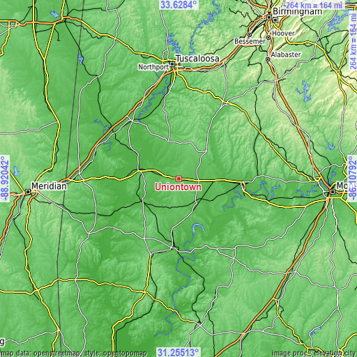
| \ | Map #1 | Topo.Map |
| Scale [m] | 47..103 m | × |
| Scale [ft] | 154..338 ft | × |
| Average | 72.6 m = 238 ft | × |
| Width | 8.25 km = 5.1 mi | 263.9 km = 164 mi |
| Height | 8.25 km = 5.1 mi | 263.9 km = 164 mi |
| ↑Max Latitude | 32.486656° | 33.6284° |
| Latitude at center | 32.44958° | 32.44958° |
| ↓Min Latitude | 32.412489° | 31.25513° |
| ← Min Longitude | -87.558115° | -88.92042° |
| Longitude center | -87.51417° | -87.51417° |
| →Max Longitude | -87.470225° | -86.10792° |
Nearby cities:
Cities around Uniontown sort by population:
• Selma elevation 45 m
46.5 km,  95°
95°
• Demopolis 40 m
31.2 km,  284°
284°
• Brent 74 m
63.3 km,  31°
31°
• Thomasville 121 m
63.2 km,  199°
199°
• Valley Grande 116 m
49.8 km,  82°
82°
• Marion 116 m
27.3 km,  41°
41°
• Eutaw 69 m
55.8 km,  321°
321°
• Selmont-West Selmont 35 m
48.2 km, 99°
• Moundville 52 m
61.9 km,  349°
349°
• Greensboro 87 m
29.3 km,  344°
344°
• Linden 51 m
31.1 km,  239°
239°
• Camden 66 m
55.2 km,  157°
157°
Multilingual:
 En español:
Uniontown elevación 92 m.
 En France:
Uniontown élévation 92 m.
 Auf Deutsch:
Uniontown höhe über dem Meeresspiegel ist 92 m.

Sources and notes:
- [note 1] Map square and city borders are not equal. Map elevation data is calculated only from area inside that square.
- [src 1] Elevation data from geonames database provided with same terms of usage.
- [src 2] The elevation map of Uniontown is generated using elevation data from NASA's 3 arcsec (90m) resolution SRTM data.
- [src 3] Base (background) map © OpenStreetMap contributors tiles are generated by Geofabrik and OpenTopoMap.
Copyright & License:
This Uniontown Elevation Map is licensed under CC BY-SA. You may reuse any part from this page, if you give a proper credit by linking to this URL:
 More info on terms of use page.