Greensboro elevation
Greensboro (Alabama, Hale County), United States elevation is 87 meters and Greensboro elevation in feet is 285 ft above sea level [src 1]. Greensboro is a seat of a second-order administrative division (feature code) with elevation that is 192 meters (630 ft) smaller than average city elevation in United States.
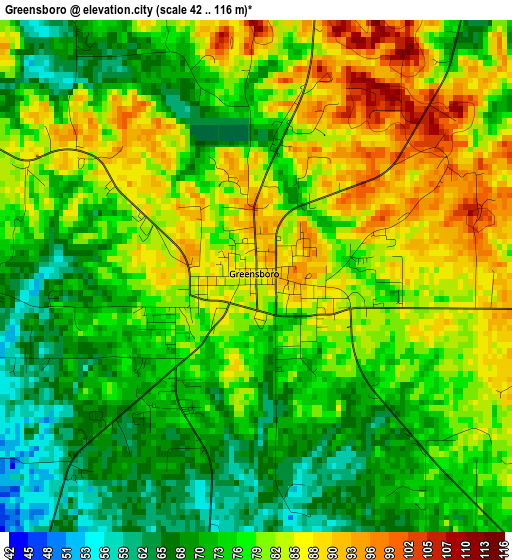
Below is the Elevation map of Greensboro, which displays elevation range with different colors. Scale of the first map is from 42 to 116 m (138 to 381 ft) with average elevation of 77.8 meters (=255 ft) [note 1]
These maps also provides idea of topography and contour of this city, they are displayed at different zoom levels. More info about maps, scale and edge coordinates you can find below images.
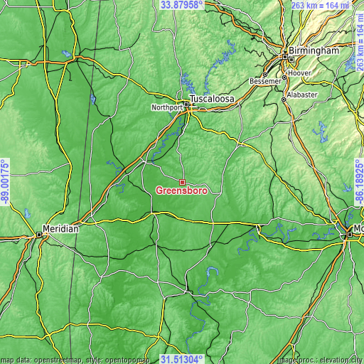
| \ | Map #1 | Topo.Map |
| Scale [m] | 42..116 m | × |
| Scale [ft] | 138..381 ft | × |
| Average | 77.8 m = 255 ft | × |
| Width | 8.22 km = 5.1 mi | 263.1 km = 163.5 mi |
| Height | 8.22 km = 5.1 mi | 263.1 km = 163.5 mi |
| ↑Max Latitude | 32.741121° | 33.87958° |
| Latitude at center | 32.70415° | 32.70415° |
| ↓Min Latitude | 32.667164° | 31.51304° |
| ← Min Longitude | -87.639445° | -89.00175° |
| Longitude center | -87.5955° | -87.5955° |
| →Max Longitude | -87.551555° | -86.18925° |
Nearby cities:
Cities around Greensboro sort by population:
• Tuscaloosa elevation 69 m
56.3 km,  2°
2°
• Northport 69 m
58.4 km, 1°
• Demopolis 40 m
30.6 km,  227°
227°
• Brent 74 m
47.9 km,  57°
57°
• Marion 116 m
27.1 km,  107°
107°
• Livingston 49 m
57 km,  256°
256°
• Eutaw 69 m
31.2 km,  299°
299°
• Centreville 115 m
52.2 km, 58°
• Moundville 52 m
32.8 km,  354°
354°
• Uniontown 92 m
29.3 km,  164°
164°
• Linden 51 m
48.1 km,  203°
203°
• Coaling 125 m
55.9 km,  25°
25°
Multilingual:
 En español:
Greensboro elevación 87 m.
 En France:
Greensboro élévation 87 m.
 Auf Deutsch:
Greensboro höhe über dem Meeresspiegel ist 87 m.

Sources and notes:
- [note 1] Map square and city borders are not equal. Map elevation data is calculated only from area inside that square.
- [src 1] Elevation data from geonames database provided with same terms of usage.
- [src 2] The elevation map of Greensboro is generated using elevation data from NASA's 3 arcsec (90m) resolution SRTM data.
- [src 3] Base (background) map © OpenStreetMap contributors tiles are generated by Geofabrik and OpenTopoMap.
Copyright & License:
This Greensboro Elevation Map is licensed under CC BY-SA. You may reuse any part from this page, if you give a proper credit by linking to this URL:
 More info on terms of use page.