Livingston elevation
Livingston (Alabama, Sumter County), United States elevation is 49 meters and Livingston elevation in feet is 161 ft above sea level [src 1]. Livingston is a seat of a second-order administrative division (feature code) with elevation that is 230 meters (755 ft) smaller than average city elevation in United States.
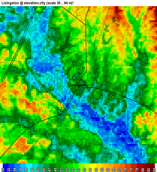
Below is the Elevation map of Livingston, which displays elevation range with different colors. Scale of the first map is from 30 to 84 m (98 to 276 ft) with average elevation of 51.1 meters (=168 ft) [note 1]
These maps also provides idea of topography and contour of this city, they are displayed at different zoom levels. More info about maps, scale and edge coordinates you can find below images.
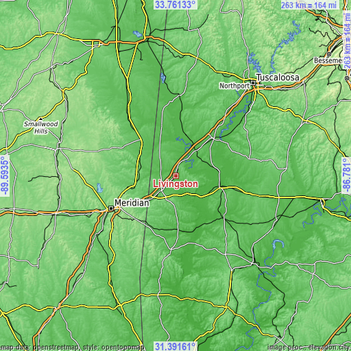
| \ | Map #1 | Topo.Map |
| Scale [m] | 30..84 m | × |
| Scale [ft] | 98..276 ft | × |
| Average | 51.1 m = 168 ft | × |
| Width | 8.23 km = 5.1 mi | 263.5 km = 163.7 mi |
| Height | 8.23 km = 5.1 mi | 263.5 km = 163.7 mi |
| ↑Max Latitude | 32.621321° | 33.76133° |
| Latitude at center | 32.5843° | 32.5843° |
| ↓Min Latitude | 32.547264° | 31.39161° |
| ← Min Longitude | -88.231195° | -89.5935° |
| Longitude center | -88.18725° | -88.18725° |
| →Max Longitude | -88.143305° | -86.781° |
Nearby cities:
Cities around Livingston sort by population:
• Meridian elevation 103 m
54.3 km,  243°
243°
• Demopolis 40 m
33.7 km,  102°
102°
• Eutaw 69 m
40 km,  44°
44°
• York 52 m
15 km,  223°
223°
• Greensboro 87 m
57 km,  76°
76°
• Aliceville 61 m
60.7 km,  3°
3°
• Linden 51 m
47.8 km,  130°
130°
• Butler 56 m
55.1 km,  183°
183°
• Marion 114 m
47 km,  246°
246°
• Nellieburg 102 m
58.7 km, 250°
• Meridian Station 93 m
40.6 km,  264°
264°
• De Kalb 141 m
47.9 km,  295°
295°
Multilingual:
 En español:
Livingston elevación 49 m.
 En France:
Livingston élévation 49 m.
 Auf Deutsch:
Livingston höhe über dem Meeresspiegel ist 49 m.

Sources and notes:
- [note 1] Map square and city borders are not equal. Map elevation data is calculated only from area inside that square.
- [src 1] Elevation data from geonames database provided with same terms of usage.
- [src 2] The elevation map of Livingston is generated using elevation data from NASA's 3 arcsec (90m) resolution SRTM data.
- [src 3] Base (background) map © OpenStreetMap contributors tiles are generated by Geofabrik and OpenTopoMap.
Copyright & License:
This Livingston Elevation Map is licensed under CC BY-SA. You may reuse any part from this page, if you give a proper credit by linking to this URL:
 More info on terms of use page.