Nellieburg elevation
Nellieburg (Mississippi, Lauderdale County), United States elevation is 102 meters and Nellieburg elevation in feet is 335 ft above sea level [src 1]. Nellieburg is a populated place (feature code) with elevation that is 177 meters (581 ft) smaller than average city elevation in United States.
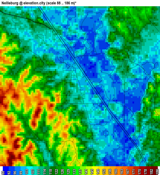
Below is the Elevation map of Nellieburg, which displays elevation range with different colors. Scale of the first map is from 88 to 186 m (289 to 610 ft) with average elevation of 118.2 meters (=388 ft) [note 1]
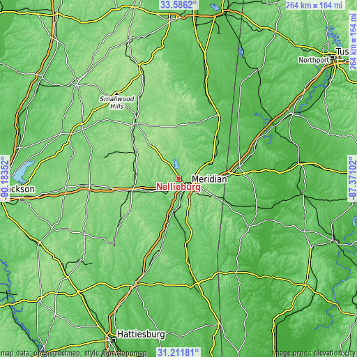
These maps also provides idea of topography and contour of this city, they are displayed at different zoom levels. More info about maps, scale and edge coordinates you can find below images.
| \ | Map #1 | Topo.Map |
| Scale [m] | 88..186 m | × |
| Scale [ft] | 289..610 ft | × |
| Average | 118.2 m = 388 ft | × |
| Width | 8.25 km = 5.1 mi | 264 km = 164 mi |
| Height | 8.25 km = 5.1 mi | 264 km = 164 mi |
| ↑Max Latitude | 32.443904° | 33.5862° |
| Latitude at center | 32.40681° | 32.40681° |
| ↓Min Latitude | 32.369701° | 31.21181° |
| ← Min Longitude | -88.821215° | -90.18352° |
| Longitude center | -88.77727° | -88.77727° |
| →Max Longitude | -88.733325° | -87.37102° |
Nearby cities:
Cities around Nellieburg sort by population:
• Meridian elevation 103 m
8.4 km,  124°
124°
• Newton 130 m
37.5 km,  255°
255°
• York 52 m
46 km,  78°
78°
• Quitman 72 m
41 km,  173°
173°
• Union 151 m
37.1 km,  299°
299°
• Collinsville 137 m
12 km,  327°
327°
• Decatur 135 m
31.3 km,  276°
276°
• Marion 114 m
12.2 km, 84°
• Conehatta 154 m
47.9 km, 275°
• Meridian Station 93 m
21.8 km,  42°
42°
• De Kalb 141 m
41.8 km,  16°
16°
• Stonewall 71 m
30.6 km,  182°
182°
Multilingual:
 En español:
Nellieburg elevación 102 m.
 En France:
Nellieburg élévation 102 m.
 Auf Deutsch:
Nellieburg höhe über dem Meeresspiegel ist 102 m.

Sources and notes:
- [note 1] Map square and city borders are not equal. Map elevation data is calculated only from area inside that square.
- [src 1] Elevation data from geonames database provided with same terms of usage.
- [src 2] The elevation map of Nellieburg is generated using elevation data from NASA's 3 arcsec (90m) resolution SRTM data.
- [src 3] Base (background) map © OpenStreetMap contributors tiles are generated by Geofabrik and OpenTopoMap.
Copyright & License:
This Nellieburg Elevation Map is licensed under CC BY-SA. You may reuse any part from this page, if you give a proper credit by linking to this URL:
 More info on terms of use page.