Selmont-West Selmont elevation
Selmont-West Selmont (Alabama, Dallas County), United States elevation is 35 meters and Selmont-West Selmont elevation in feet is 115 ft above sea level [src 1]. Selmont-West Selmont is a populated place (feature code) with elevation that is 244 meters (801 ft) smaller than average city elevation in United States.
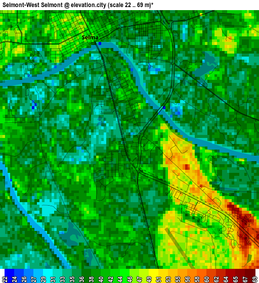
Below is the Elevation map of Selmont-West Selmont, which displays elevation range with different colors. Scale of the first map is from 22 to 69 m (72 to 226 ft) with average elevation of 39.4 meters (=129 ft) [note 1]
These maps also provides idea of topography and contour of this city, they are displayed at different zoom levels. More info about maps, scale and edge coordinates you can find below images.
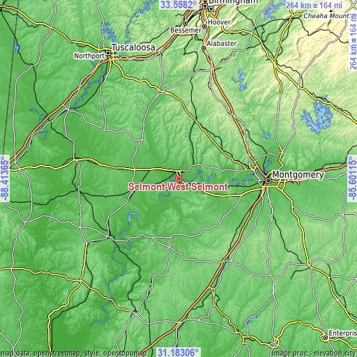
| \ | Map #1 | Topo.Map |
| Scale [m] | 22..69 m | × |
| Scale [ft] | 72..226 ft | × |
| Average | 39.4 m = 129 ft | × |
| Width | 8.25 km = 5.1 mi | 264.1 km = 164.1 mi |
| Height | 8.25 km = 5.1 mi | 264.1 km = 164.1 mi |
| ↑Max Latitude | 32.415535° | 33.5582° |
| Latitude at center | 32.37843° | 32.37843° |
| ↓Min Latitude | 32.341309° | 31.18306° |
| ← Min Longitude | -87.051345° | -88.41365° |
| Longitude center | -87.0074° | -87.0074° |
| →Max Longitude | -86.963455° | -85.60115° |
Nearby cities:
Cities around Selmont-West Selmont sort by population:
• Prattville elevation 109 m
52.3 km,  79°
79°
• Selma 45 m
3.5 km,  338°
338°
• Millbrook 63 m
61.6 km, 79°
• Clanton 178 m
62.2 km,  34°
34°
• Pine Level 179 m
55.7 km,  65°
65°
• Valley Grande 116 m
14.6 km,  7°
7°
• Marion 116 m
40.6 km,  314°
314°
• Uniontown 92 m
48.2 km,  279°
279°
• Camden 66 m
50.7 km,  211°
211°
• Marbury 164 m
61.8 km,  54°
54°
• Fort Deposit 144 m
59.5 km,  137°
137°
• Hayneville 78 m
45.6 km,  118°
118°
Multilingual:
 En español:
Selmont-West Selmont elevación 35 m.
 En France:
Selmont-West Selmont élévation 35 m.
 Auf Deutsch:
Selmont-West Selmont höhe über dem Meeresspiegel ist 35 m.
 На русском:
Selmont-West Selmont высота над уровнем моря 35 м
Sources and notes:
- [note 1] Map square and city borders are not equal. Map elevation data is calculated only from area inside that square.
- [src 1] Elevation data from geonames database provided with same terms of usage.
- [src 2] The elevation map of Selmont-West Selmont is generated using elevation data from NASA's 3 arcsec (90m) resolution SRTM data.
- [src 3] Base (background) map © OpenStreetMap contributors tiles are generated by Geofabrik and OpenTopoMap.
Copyright & License:
This Selmont-West Selmont Elevation Map is licensed under CC BY-SA. You may reuse any part from this page, if you give a proper credit by linking to this URL:
 More info on terms of use page.