Pine Level elevation
Pine Level (Alabama, Autauga County), United States elevation is 179 meters and Pine Level elevation in feet is 587 ft above sea level [src 1]. Pine Level is a populated place (feature code) with elevation that is 100 meters (328 ft) smaller than average city elevation in United States.
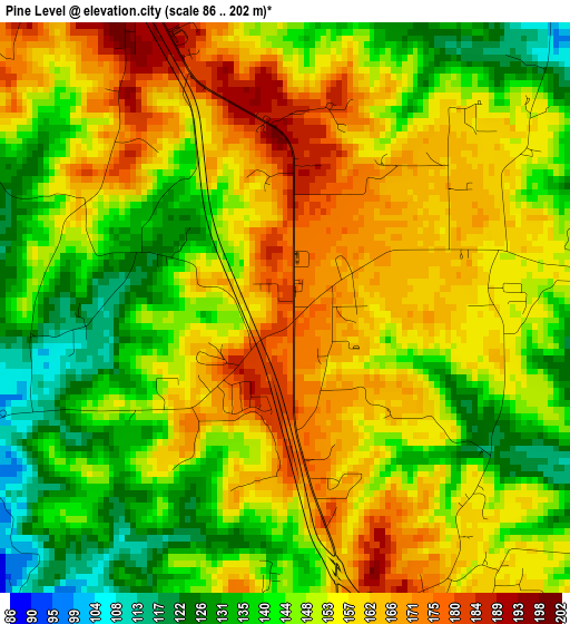
Below is the Elevation map of Pine Level, which displays elevation range with different colors. Scale of the first map is from 86 to 202 m (282 to 663 ft) with average elevation of 151.2 meters (=496 ft) [note 1]
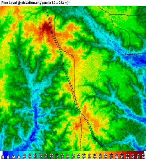
These maps also provides idea of topography and contour of this city, they are displayed at different zoom levels. More info about maps, scale and edge coordinates you can find below images.
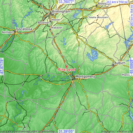
| \ | Map #1 | Map #2 | Topo.Map |
| Scale [m] | 86..202 m | 80..233 m | × |
| Scale [ft] | 282..663 ft | 262..764 ft | × |
| Average | 151.2 m = 496 ft | 143.2 m = 470 ft | × |
| Width | 8.23 km = 5.1 mi | 16.47 km = 10.2 mi | 263.5 km = 163.7 mi |
| Height | 8.23 km = 5.1 mi | 16.47 km = 10.2 mi | 263.5 km = 163.7 mi |
| ↑Max Latitude | 32.620761° | 32.657767° | 33.76077° |
| Latitude at center | 32.58374° | 32.58374° | 32.58374° |
| ↓Min Latitude | 32.546704° | 32.509652° | 31.39105° |
| ← Min Longitude | -86.509475° | -86.553421° | -87.87178° |
| Longitude center | -86.46553° | -86.46553° | -86.46553° |
| →Max Longitude | -86.421585° | -86.377639° | -85.05928° |
Nearby cities:
Cities around Pine Level sort by population:
• Montgomery elevation 76 m
28.7 km,  147°
147°
• Prattville 109 m
13.3 km,  177°
177°
• Millbrook 63 m
15.1 km,  139°
139°
• Clanton 178 m
32.2 km,  331°
331°
• Wetumpka 58 m
24.2 km,  100°
100°
• Holtville 110 m
14.3 km,  65°
65°
• Emerald Mountain 106 m
37.9 km,  113°
113°
• Marbury 164 m
13.1 km,  357°
357°
• Blue Ridge 123 m
27.7 km, 111°
• Elmore 64 m
15 km, 109°
• Coosada 56 m
15.8 km,  127°
127°
• Deatsville 100 m
7.1 km, 67°
Multilingual:
 En español:
Pine Level elevación 179 m.
 En France:
Pine Level élévation 179 m.
 Auf Deutsch:
Pine Level höhe über dem Meeresspiegel ist 179 m.

Sources and notes:
- [note 1] Map square and city borders are not equal. Map elevation data is calculated only from area inside that square.
- [src 1] Elevation data from geonames database provided with same terms of usage.
- [src 2] The elevation map of Pine Level is generated using elevation data from NASA's 3 arcsec (90m) resolution SRTM data.
- [src 3] Base (background) map © OpenStreetMap contributors tiles are generated by Geofabrik and OpenTopoMap.
Copyright & License:
This Pine Level Elevation Map is licensed under CC BY-SA. You may reuse any part from this page, if you give a proper credit by linking to this URL:
 More info on terms of use page.