Clanton elevation
Clanton (Alabama, Chilton County), United States elevation is 178 meters and Clanton elevation in feet is 584 ft above sea level [src 1]. Clanton is a seat of a second-order administrative division (feature code) with elevation that is 101 meters (331 ft) smaller than average city elevation in United States.
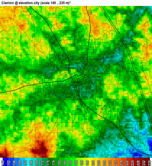
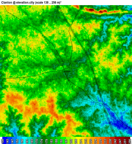
Below is the Elevation map of Clanton, which displays elevation range with different colors. Scale of the first map is from 149 to 235 m (489 to 771 ft) with average elevation of 188 meters (=617 ft) [note 1]
These maps also provides idea of topography and contour of this city, they are displayed at different zoom levels. More info about maps, scale and edge coordinates you can find below images.
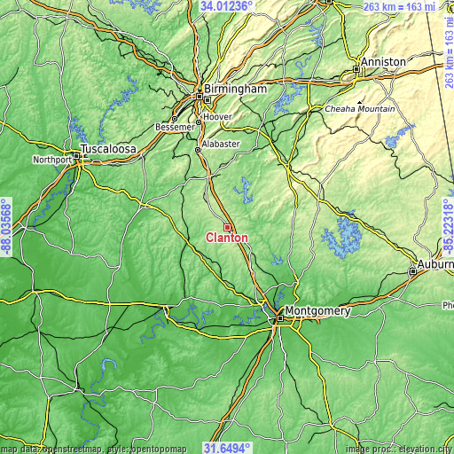
| \ | Map #1 | Map #2 | Topo.Map |
| Scale [m] | 149..235 m | 138..256 m | × |
| Scale [ft] | 489..771 ft | 453..840 ft | × |
| Average | 188 m = 617 ft | 188.8 m = 619 ft | × |
| Width | 8.21 km = 5.1 mi | 16.42 km = 10.2 mi | 262.7 km = 163.2 mi |
| Height | 8.21 km = 5.1 mi | 16.42 km = 10.2 mi | 262.7 km = 163.2 mi |
| ↑Max Latitude | 32.875655° | 32.912555° | 34.01236° |
| Latitude at center | 32.83874° | 32.83874° | 32.83874° |
| ↓Min Latitude | 32.801809° | 32.764864° | 31.6494° |
| ← Min Longitude | -86.673375° | -86.717321° | -88.03568° |
| Longitude center | -86.62943° | -86.62943° | -86.62943° |
| →Max Longitude | -86.585485° | -86.541539° | -85.22318° |
Nearby cities:
Cities around Clanton sort by population:
• Calera elevation 156 m
31.6 km,  338°
338°
• Montevallo 125 m
36.4 km,  323°
323°
• Pine Level 179 m
32.2 km,  151°
151°
• Columbiana 167 m
37.8 km,  3°
3°
• Holtville 110 m
36.2 km,  128°
128°
• Jemison 219 m
17.4 km, 320°
• Thorsby 210 m
11.8 km, 316°
• Marbury 164 m
21.3 km,  135°
135°
• Fayetteville 134 m
40 km,  31°
31°
• Deatsville 100 m
33.7 km, 139°
• Shelby 152 m
30.5 km,  7°
7°
• Rockford 224 m
38.7 km,  81°
81°
Multilingual:
 En español:
Clanton elevación 178 m.
 En France:
Clanton élévation 178 m.


Sources and notes:
- [note 1] Map square and city borders are not equal. Map elevation data is calculated only from area inside that square.
- [src 1] Elevation data from geonames database provided with same terms of usage.
- [src 2] The elevation map of Clanton is generated using elevation data from NASA's 3 arcsec (90m) resolution SRTM data.
- [src 3] Base (background) map © OpenStreetMap contributors tiles are generated by Geofabrik and OpenTopoMap.
Copyright & License:
This Clanton Elevation Map is licensed under CC BY-SA. You may reuse any part from this page, if you give a proper credit by linking to this URL:
 More info on terms of use page.