Thorsby elevation
Thorsby (Alabama, Chilton County), United States elevation is 210 meters and Thorsby elevation in feet is 689 ft above sea level [src 1]. Thorsby is a populated place (feature code) with elevation that is 69 meters (226 ft) smaller than average city elevation in United States.
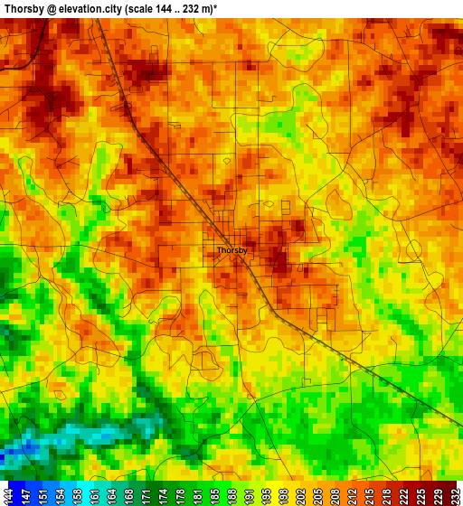
Below is the Elevation map of Thorsby, which displays elevation range with different colors. Scale of the first map is from 144 to 232 m (472 to 761 ft) with average elevation of 200.4 meters (=657 ft) [note 1]
These maps also provides idea of topography and contour of this city, they are displayed at different zoom levels. More info about maps, scale and edge coordinates you can find below images.
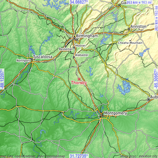
| \ | Map #1 | Topo.Map |
| Scale [m] | 144..232 m | × |
| Scale [ft] | 472..761 ft | × |
| Average | 200.4 m = 657 ft | × |
| Width | 8.2 km = 5.1 mi | 262.5 km = 163.1 mi |
| Height | 8.2 km = 5.1 mi | 262.5 km = 163.1 mi |
| ↑Max Latitude | 32.952563° | 34.08827° |
| Latitude at center | 32.91568° | 32.91568° |
| ↓Min Latitude | 32.878781° | 31.72735° |
| ← Min Longitude | -86.759765° | -88.12207° |
| Longitude center | -86.71582° | -86.71582° |
| →Max Longitude | -86.671875° | -85.30957° |
Nearby cities:
Cities around Thorsby sort by population:
• Alabaster elevation 145 m
37.7 km,  345°
345°
• Calera 156 m
21.1 km, 350°
• Clanton 178 m
11.8 km,  136°
136°
• Montevallo 125 m
24.8 km,  326°
326°
• Brent 74 m
42 km,  273°
273°
• Columbiana 167 m
30.9 km,  19°
19°
• Centreville 115 m
37.6 km,  275°
275°
• Jemison 219 m
5.7 km, 329°
• Wilsonville 131 m
41.5 km,  31°
31°
• Marbury 164 m
33 km, 136°
• Fayetteville 134 m
38.6 km,  48°
48°
• Shelby 152 m
24.9 km, 29°
Multilingual:
 En español:
Thorsby elevación 210 m.
 En France:
Thorsby élévation 210 m.


Sources and notes:
- [note 1] Map square and city borders are not equal. Map elevation data is calculated only from area inside that square.
- [src 1] Elevation data from geonames database provided with same terms of usage.
- [src 2] The elevation map of Thorsby is generated using elevation data from NASA's 3 arcsec (90m) resolution SRTM data.
- [src 3] Base (background) map © OpenStreetMap contributors tiles are generated by Geofabrik and OpenTopoMap.
Copyright & License:
This Thorsby Elevation Map is licensed under CC BY-SA. You may reuse any part from this page, if you give a proper credit by linking to this URL:
 More info on terms of use page.