Selma elevation
Selma (Alabama, Dallas County), United States elevation is 45 meters and Selma elevation in feet is 148 ft above sea level [src 1]. Selma is a seat of a second-order administrative division (feature code) with elevation that is 234 meters (768 ft) smaller than average city elevation in United States.
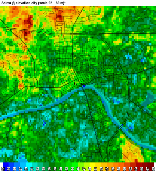
Below is the Elevation map of Selma, which displays elevation range with different colors. Scale of the first map is from 22 to 69 m (72 to 226 ft) with average elevation of 40.8 meters (=134 ft) [note 1]
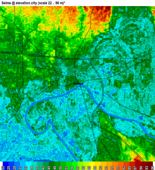
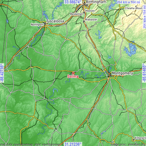
These maps also provides idea of topography and contour of this city, they are displayed at different zoom levels. More info about maps, scale and edge coordinates you can find below images.
| \ | Map #1 | Map #2 | Topo.Map |
| Scale [m] | 22..69 m | 22..96 m | × |
| Scale [ft] | 72..226 ft | 72..315 ft | × |
| Average | 40.8 m = 134 ft | 44.8 m = 147 ft | × |
| Width | 8.25 km = 5.1 mi | 16.5 km = 10.3 mi | 264 km = 164 mi |
| Height | 8.25 km = 5.1 mi | 16.5 km = 10.3 mi | 264 km = 164 mi |
| ↑Max Latitude | 32.444454° | 32.481532° | 33.58674° |
| Latitude at center | 32.40736° | 32.40736° | 32.40736° |
| ↓Min Latitude | 32.370251° | 32.333127° | 31.21236° |
| ← Min Longitude | -87.065045° | -87.108991° | -88.42735° |
| Longitude center | -87.0211° | -87.0211° | -87.0211° |
| →Max Longitude | -86.977155° | -86.933209° | -85.61485° |
Nearby cities:
Cities around Selma sort by population:
• Prattville elevation 109 m
53.1 km,  83°
83°
• Clanton 178 m
60.4 km,  37°
37°
• Brent 74 m
60.4 km,  347°
347°
• Pine Level 179 m
55.7 km,  69°
69°
• Valley Grande 116 m
11.7 km,  15°
15°
• Marion 116 m
37.5 km,  311°
311°
• Centreville 115 m
60.6 km, 351°
• Selmont-West Selmont 35 m
3.5 km,  158°
158°
• Uniontown 92 m
46.5 km,  275°
275°
• Camden 66 m
52.8 km,  208°
208°
• Marbury 164 m
61 km,  57°
57°
• Hayneville 78 m
48.3 km,  120°
120°
Multilingual:
 En español:
Selma elevación 45 m.
 En France:
Selma élévation 45 m.


Sources and notes:
- [note 1] Map square and city borders are not equal. Map elevation data is calculated only from area inside that square.
- [src 1] Elevation data from geonames database provided with same terms of usage.
- [src 2] The elevation map of Selma is generated using elevation data from NASA's 3 arcsec (90m) resolution SRTM data.
- [src 3] Base (background) map © OpenStreetMap contributors tiles are generated by Geofabrik and OpenTopoMap.
Copyright & License:
This Selma Elevation Map is licensed under CC BY-SA. You may reuse any part from this page, if you give a proper credit by linking to this URL:
 More info on terms of use page.