Ekpoma elevation
Ekpoma (Edo, Esan West), Nigeria elevation is 364 meters and Ekpoma elevation in feet is 1194 ft above sea level [src 1]. Ekpoma is a seat of a second-order administrative division (feature code) with elevation that is 67 meters (220 ft) bigger than average city elevation in Nigeria.
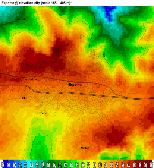
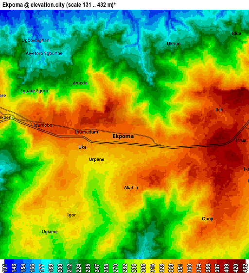
Below is the Elevation map of Ekpoma, which displays elevation range with different colors. Scale of the first map is from 185 to 405 m (607 to 1329 ft) with average elevation of 327.9 meters (=1076 ft) [note 1]
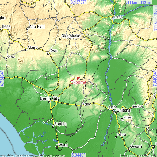
These maps also provides idea of topography and contour of this city, they are displayed at different zoom levels. More info about maps, scale and edge coordinates you can find below images.
| \ | Map #1 | Map #2 | Topo.Map |
| Scale [m] | 185..405 m | 131..432 m | × |
| Scale [ft] | 607..1329 ft | 430..1417 ft | × |
| Average | 327.9 m = 1076 ft | 294.1 m = 965 ft | × |
| Width | 9.7 km = 6 mi | 19.41 km = 12.1 mi | 310.5 km = 192.9 mi |
| Height | 9.7 km = 6 mi | 19.41 km = 12.1 mi | 310.6 km = 193 mi |
| ↑Max Latitude | 6.786639° | 6.830275° | 8.13737° |
| Latitude at center | 6.743° | 6.743° | 6.743° |
| ↓Min Latitude | 6.699357° | 6.65571° | 5.3446° |
| ← Min Longitude | 6.096345° | 6.052399° | 4.73404° |
| Longitude center | 6.14029° | 6.14029° | 6.14029° |
| →Max Longitude | 6.184235° | 6.228181° | 7.54654° |
Nearby cities:
Cities around Ekpoma sort by population:
• Uromi elevation 381 m
21.8 km,  102°
102°
• Agbor 130 m
54.7 km,  173°
173°
• Auchi 188 m
38.6 km,  20°
20°
• Ubiaja 286 m
28.7 km,  109°
109°
• Ifon 184 m
45.5 km,  297°
297°
• Illushi 32 m
54.6 km, 98°
• Abudu 57 m
51.3 km,  193°
193°
• Sabongida-Ora 84 m
29.1 km,  307°
307°
• Afuze 134 m
27.4 km,  336°
336°
• Ehor 245 m
22.5 km,  230°
230°
• Igueben 286 m
19.4 km,  144°
144°
• Irrua 398 m
8.8 km,  94°
94°
Multilingual:
 En español:
Ekpoma elevación 364 m.
 En France:
Ekpoma élévation 364 m.


Sources and notes:
- [note 1] Map square and city borders are not equal. Map elevation data is calculated only from area inside that square.
- [src 1] Elevation data from geonames database provided with same terms of usage.
- [src 2] The elevation map of Ekpoma is generated using elevation data from NASA's 3 arcsec (90m) resolution SRTM data.
- [src 3] Base (background) map © OpenStreetMap contributors tiles are generated by Geofabrik and OpenTopoMap.
Copyright & License:
This Ekpoma Elevation Map is licensed under CC BY-SA. You may reuse any part from this page, if you give a proper credit by linking to this URL:
 More info on terms of use page.