Auchi elevation
Auchi (Edo, Etsako West), Nigeria elevation is 188 meters and Auchi elevation in feet is 617 ft above sea level [src 1]. Auchi is a seat of a second-order administrative division (feature code) with elevation that is 109 meters (358 ft) smaller than average city elevation in Nigeria.
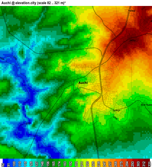
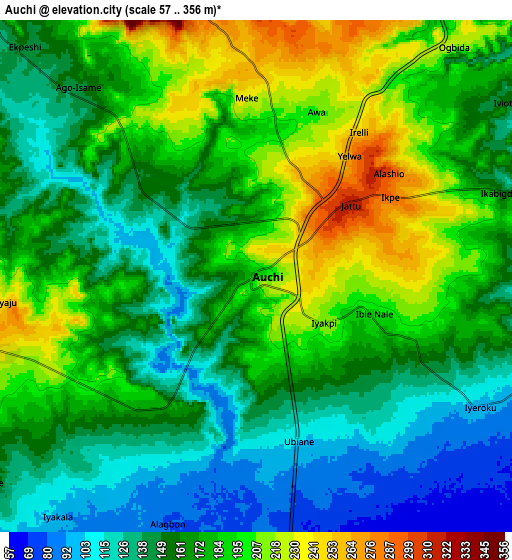
Below is the Elevation map of Auchi, which displays elevation range with different colors. Scale of the first map is from 82 to 321 m (269 to 1053 ft) with average elevation of 182.2 meters (=598 ft) [note 1]
These maps also provides idea of topography and contour of this city, they are displayed at different zoom levels. More info about maps, scale and edge coordinates you can find below images.
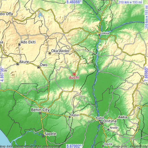
| \ | Map #1 | Map #2 | Topo.Map |
| Scale [m] | 82..321 m | 57..356 m | × |
| Scale [ft] | 269..1053 ft | 187..1168 ft | × |
| Average | 182.2 m = 598 ft | 167.3 m = 549 ft | × |
| Width | 9.7 km = 6 mi | 19.4 km = 12.1 mi | 310.3 km = 192.8 mi |
| Height | 9.7 km = 6 mi | 19.4 km = 12.1 mi | 310.3 km = 192.8 mi |
| ↑Max Latitude | 7.111169° | 7.154775° | 8.46088° |
| Latitude at center | 7.06756° | 7.06756° | 7.06756° |
| ↓Min Latitude | 7.023947° | 6.980329° | 5.67002° |
| ← Min Longitude | 6.219655° | 6.175709° | 4.85735° |
| Longitude center | 6.2636° | 6.2636° | 6.2636° |
| →Max Longitude | 6.307545° | 6.351491° | 7.66985° |
Nearby cities:
Cities around Auchi sort by population:
• Uromi elevation 381 m
41.6 km,  169°
169°
• Ekpoma 364 m
38.6 km,  200°
200°
• Ubiaja 286 m
47.7 km,  163°
163°
• Igarra 296 m
30.7 km,  325°
325°
• Agenebode 55 m
47.7 km,  84°
84°
• Igueben 286 m
51.8 km,  182°
182°
• Onyedega 32 m
50 km,  114°
114°
• Akpafa 361 m
46.7 km,  344°
344°
• Sabongida-Ora 84 m
41 km,  243°
243°
• Irrua 398 m
37.1 km,  187°
187°
• Afuze 134 m
26.7 km,  245°
245°
• Fugar 241 m
26 km, 84°
Multilingual:
 En español:
Auchi elevación 188 m.
 En France:
Auchi élévation 188 m.


Sources and notes:
- [note 1] Map square and city borders are not equal. Map elevation data is calculated only from area inside that square.
- [src 1] Elevation data from geonames database provided with same terms of usage.
- [src 2] The elevation map of Auchi is generated using elevation data from NASA's 3 arcsec (90m) resolution SRTM data.
- [src 3] Base (background) map © OpenStreetMap contributors tiles are generated by Geofabrik and OpenTopoMap.
Copyright & License:
This Auchi Elevation Map is licensed under CC BY-SA. You may reuse any part from this page, if you give a proper credit by linking to this URL:
 More info on terms of use page.