Sabongida-Ora elevation
Sabongida-Ora (Edo, Owan West), Nigeria elevation is 84 meters and Sabongida-Ora elevation in feet is 276 ft above sea level [src 1]. Sabongida-Ora is a seat of a second-order administrative division (feature code) with elevation that is 213 meters (699 ft) smaller than average city elevation in Nigeria.
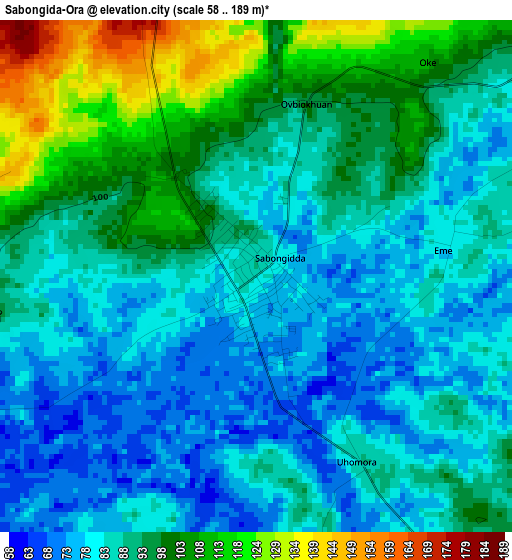
Below is the Elevation map of Sabongida-Ora, which displays elevation range with different colors. Scale of the first map is from 58 to 189 m (190 to 620 ft) with average elevation of 90.6 meters (=297 ft) [note 1]
These maps also provides idea of topography and contour of this city, they are displayed at different zoom levels. More info about maps, scale and edge coordinates you can find below images.
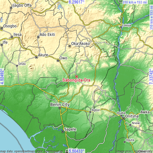
| \ | Map #1 | Topo.Map |
| Scale [m] | 58..189 m | × |
| Scale [ft] | 190..620 ft | × |
| Average | 90.6 m = 297 ft | × |
| Width | 9.7 km = 6 mi | 310.4 km = 192.9 mi |
| Height | 9.7 km = 6 mi | 310.5 km = 192.9 mi |
| ↑Max Latitude | 6.945935° | 8.29617° |
| Latitude at center | 6.90231° | 6.90231° |
| ↓Min Latitude | 6.858681° | 5.50433° |
| ← Min Longitude | 5.887225° | 4.52492° |
| Longitude center | 5.93117° | 5.93117° |
| →Max Longitude | 5.975115° | 7.33742° |
Nearby cities:
Cities around Sabongida-Ora sort by population:
• Owo elevation 348 m
50.1 km,  310°
310°
• Uromi 381 m
49.8 km,  116°
116°
• Auchi 188 m
41 km,  63°
63°
• Ekpoma 364 m
29.1 km,  127°
127°
• Ubiaja 286 m
57.1 km, 118°
• Igarra 296 m
47.5 km,  23°
23°
• Ifon 184 m
17.6 km,  279°
279°
• Isua 357 m
61.3 km,  357°
357°
• Igueben 286 m
48 km, 134°
• Irrua 398 m
36.8 km, 120°
• Ehor 245 m
32.4 km,  169°
169°
• Afuze 134 m
14.4 km, 58°
Multilingual:
 En español:
Sabongida-Ora elevación 84 m.
 En France:
Sabongida-Ora élévation 84 m.
 Auf Deutsch:
Sabongida-Ora höhe über dem Meeresspiegel ist 84 m.

Sources and notes:
- [note 1] Map square and city borders are not equal. Map elevation data is calculated only from area inside that square.
- [src 1] Elevation data from geonames database provided with same terms of usage.
- [src 2] The elevation map of Sabongida-Ora is generated using elevation data from NASA's 3 arcsec (90m) resolution SRTM data.
- [src 3] Base (background) map © OpenStreetMap contributors tiles are generated by Geofabrik and OpenTopoMap.
Copyright & License:
This Sabongida-Ora Elevation Map is licensed under CC BY-SA. You may reuse any part from this page, if you give a proper credit by linking to this URL:
 More info on terms of use page.