Owo elevation
Owo (Ondo), Nigeria elevation is 348 meters and Owo elevation in feet is 1142 ft above sea level [src 1]. Owo is a seat of a second-order administrative division (feature code) with elevation that is 51 meters (167 ft) bigger than average city elevation in Nigeria.
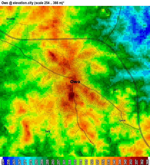
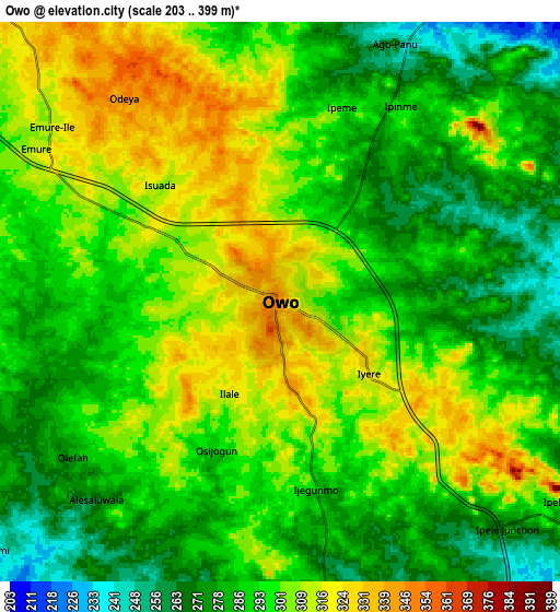
Below is the Elevation map of Owo, which displays elevation range with different colors. Scale of the first map is from 254 to 366 m (833 to 1201 ft) with average elevation of 310.7 meters (=1019 ft) [note 1]
These maps also provides idea of topography and contour of this city, they are displayed at different zoom levels. More info about maps, scale and edge coordinates you can find below images.
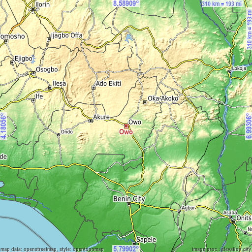
| \ | Map #1 | Map #2 | Topo.Map |
| Scale [m] | 254..366 m | 203..399 m | × |
| Scale [ft] | 833..1201 ft | 666..1309 ft | × |
| Average | 310.7 m = 1019 ft | 294.7 m = 967 ft | × |
| Width | 9.7 km = 6 mi | 19.39 km = 12 mi | 310.2 km = 192.7 mi |
| Height | 9.7 km = 6 mi | 19.39 km = 12 mi | 310.3 km = 192.8 mi |
| ↑Max Latitude | 7.239797° | 7.28339° | 8.58909° |
| Latitude at center | 7.1962° | 7.1962° | 7.1962° |
| ↓Min Latitude | 7.152599° | 7.108993° | 5.79902° |
| ← Min Longitude | 5.542865° | 5.498919° | 4.18056° |
| Longitude center | 5.58681° | 5.58681° | 5.58681° |
| →Max Longitude | 5.630755° | 5.674701° | 6.99306° |
Nearby cities:
Cities around Owo sort by population:
• Akure elevation 353 m
43.9 km,  278°
278°
• Ise-Ekiti 379 m
34.9 km,  328°
328°
• Ikere-Ekiti 381 m
51.6 km,  310°
310°
• Emure-Ekiti 379 m
30.2 km, 332°
• Ifon 184 m
36.1 km,  145°
145°
• Ode-Ekiti 416 m
50.4 km,  355°
355°
• Sabongida-Ora 84 m
50.1 km,  130°
130°
• Isua 357 m
45.8 km,  51°
51°
• Iju 368 m
42.3 km,  301°
301°
• Ita-Ogbolu 346 m
42.1 km, 297°
• Ikare 423 m
41 km,  26°
26°
• Oka 537 m
37.7 km,  38°
38°
Multilingual:
 En español:
Owo elevación 348 m.
 En France:
Owo élévation 348 m.


Sources and notes:
- [note 1] Map square and city borders are not equal. Map elevation data is calculated only from area inside that square.
- [src 1] Elevation data from geonames database provided with same terms of usage.
- [src 2] The elevation map of Owo is generated using elevation data from NASA's 3 arcsec (90m) resolution SRTM data.
- [src 3] Base (background) map © OpenStreetMap contributors tiles are generated by Geofabrik and OpenTopoMap.
Copyright & License:
This Owo Elevation Map is licensed under CC BY-SA. You may reuse any part from this page, if you give a proper credit by linking to this URL:
 More info on terms of use page.