Nigeria elevation
On our site we have elevation data and maps for 906 cities from Nigeria including Abuja as capital of the country.
Nigeria on topographic map
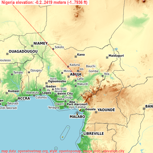
Nigeria elevation extremes
Land surface elevation extremes in Nigeria:
- Highest point in Nigeria: Chappal Waddi with 2419 meters (=7936 ft)
- Lowest point: Unnamed location on Lagos Island with -0.2 meters (=-1 ft)
- Elevation span: 2419.2 m (=7937 ft)
Statistics
- Main average elevation: 380 meters (= 1247 ft)
- Average elevation of cities: 297 m (= 974 ft), and this is 99 m (325 ft) below average city elevation worldwide..[1]
- Area: 923,768 km² (= 356,669 sq mi)
- Population: 154,000,000


This is only the list of largest 150 cities in ABC order:
If the city you are looking for is not listed, use the search box above.
Search by letter:
A B C D E F G H I J K L M N O P S U W Y Z
A:
Aba Abakaliki Abeokuta Abuja Ado-Ekiti Afikpo Agbor Agulu Aku Akure Amaigbo Apomu Aramoko-Ekiti Asaba Atani Auchi Awka Azare
B:
Bama Bauchi Bende Benin City Bida Birnin Kebbi Biu Buguma
C:
Calabar
D:
Damaturu Daura
E:
Ebute Ikorodu Effium Efon-Alaaye Eha Amufu Ejigbo Ekpoma Emure-Ekiti Enugu Enugu-Ukwu Epe Esuk Oron Ezza-Ohu
F:
Fiditi Funtua
G:
Gamboru Gashua Gbongan Gombe Gusau
H:
Hadejia
I:
Ibadan Idah Idanre Ifo Igbara-Odo Igbo-Ora Igbo-Ukwu Igboho Igede-Ekiti Ihiala Ijebu-Igbo Ijebu-Jesa Ijebu-Ode Ijero-Ekiti Ikeja Ikere-Ekiti Ikire Ikirun Ikom Ikot Ekpene Ila Orangun Ilaro Ilesa Ilobu Ilorin Inisa Ipoti Ise-Ekiti Isieke Iwo
J:
Jalingo Jega Jimeta Jos
K:
Kabba Kaduna Kafanchan Kagoro Kano Katsina Kaura Namoda Keffi Kisi Kontagora Kuje
L:
Lafia Lafiagi Lagos Lalupon Lere Lokoja
M:
Maiduguri Makoko Makurdi Malumfashi Minna Modakeke Mubi
N:
Nguru Nkpor Nkwerre Nnewi Nsukka Numan
O:
Obonoma Ode Offa Ogaminana Ohafia-Ifigh Oke Mesi Okene Okigwe Okrika Olupona Ondo Onitsha Orita Eruwa Osogbo Owerri Owo Oyan Oyo Ozubulu
P:
Pindiga Port Harcourt Potiskum
S:
Saki Sapele Shagamu Sokoto Suleja
U:
Uga Ugep Ughelli Umuahia Uromi Uyo
W:
Warri Wukari
Y:
Yola
Z:
Zaria
15 most populated cities are in red/bold font style.

A:
Aba Abakaliki Abeokuta Abuja Ado-Ekiti Afikpo Agbor Agulu Aku Akure Amaigbo Apomu Aramoko-Ekiti Asaba Atani Auchi Awka Azare
B:
Bama Bauchi Bende Benin City Bida Birnin Kebbi Biu Buguma
C:
Calabar
D:
Damaturu Daura
E:
Ebute Ikorodu Effium Efon-Alaaye Eha Amufu Ejigbo Ekpoma Emure-Ekiti Enugu Enugu-Ukwu Epe Esuk Oron Ezza-Ohu
F:
Fiditi Funtua
G:
Gamboru Gashua Gbongan Gombe Gusau
H:
Hadejia
I:
Ibadan Idah Idanre Ifo Igbara-Odo Igbo-Ora Igbo-Ukwu Igboho Igede-Ekiti Ihiala Ijebu-Igbo Ijebu-Jesa Ijebu-Ode Ijero-Ekiti Ikeja Ikere-Ekiti Ikire Ikirun Ikom Ikot Ekpene Ila Orangun Ilaro Ilesa Ilobu Ilorin Inisa Ipoti Ise-Ekiti Isieke Iwo
J:
Jalingo Jega Jimeta Jos
K:
Kabba Kaduna Kafanchan Kagoro Kano Katsina Kaura Namoda Keffi Kisi Kontagora Kuje
L:
Lafia Lafiagi Lagos Lalupon Lere Lokoja
M:
Maiduguri Makoko Makurdi Malumfashi Minna Modakeke Mubi
N:
Nguru Nkpor Nkwerre Nnewi Nsukka Numan
O:
Obonoma Ode Offa Ogaminana Ohafia-Ifigh Oke Mesi Okene Okigwe Okrika Olupona Ondo Onitsha Orita Eruwa Osogbo Owerri Owo Oyan Oyo Ozubulu
P:
Pindiga Port Harcourt Potiskum
S:
Saki Sapele Shagamu Sokoto Suleja
U:
Uga Ugep Ughelli Umuahia Uromi Uyo
W:
Warri Wukari
Y:
Yola
Z:
Zaria
Sources
- Elevation extremes by country from wikipedia.
- Base map data: © OpenStreetMap contributors, | map style: © OpenTopoMap (CC-BY-SA)
- [1] Calculated only from 906 cities in our database
- Other city data from geonames.org with taken over terms of usage.
- Min/max latitude and longitude coordinates per country from latitudelongitude.org website.