Uromi elevation
Uromi (Edo, Esan North-East), Nigeria elevation is 381 meters and Uromi elevation in feet is 1250 ft above sea level [src 1]. Uromi is a populated place (feature code) with elevation that is 84 meters (276 ft) bigger than average city elevation in Nigeria.
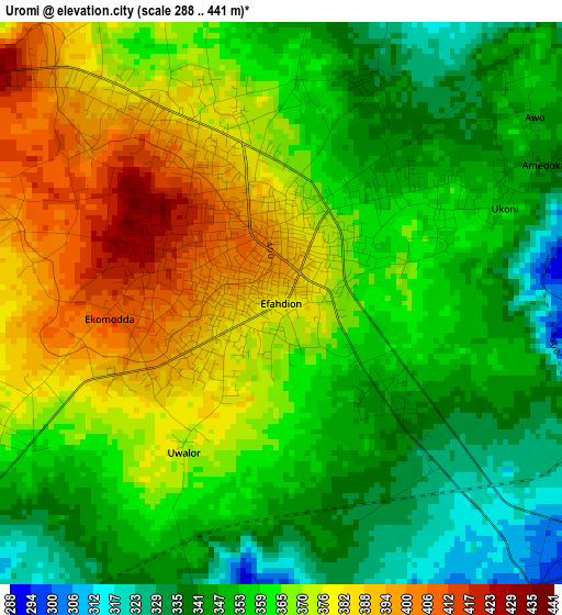
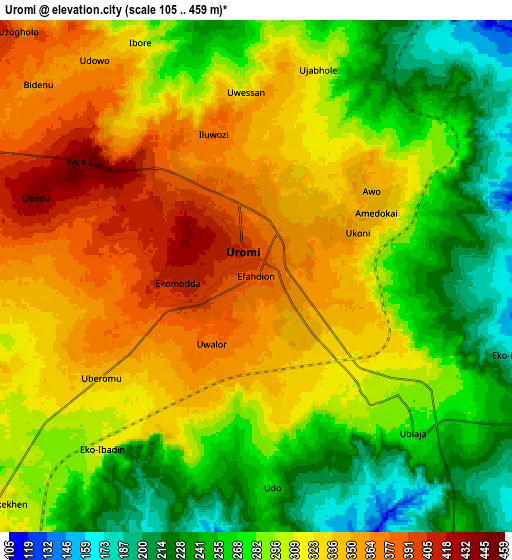
Below is the Elevation map of Uromi, which displays elevation range with different colors. Scale of the first map is from 288 to 441 m (945 to 1447 ft) with average elevation of 361.9 meters (=1187 ft) [note 1]
These maps also provides idea of topography and contour of this city, they are displayed at different zoom levels. More info about maps, scale and edge coordinates you can find below images.
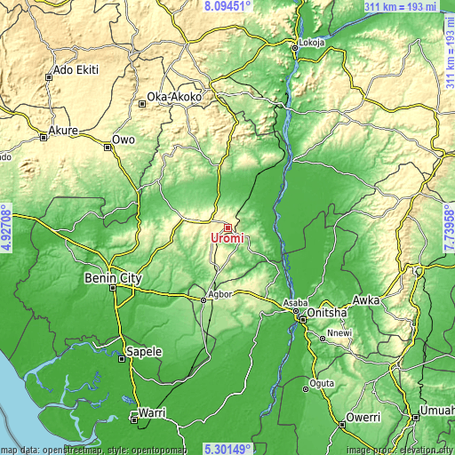
| \ | Map #1 | Map #2 | Topo.Map |
| Scale [m] | 288..441 m | 105..459 m | × |
| Scale [ft] | 945..1447 ft | 344..1506 ft | × |
| Average | 361.9 m = 1187 ft | 303.4 m = 995 ft | × |
| Width | 9.71 km = 6 mi | 19.41 km = 12.1 mi | 310.6 km = 193 mi |
| Height | 9.71 km = 6 mi | 19.41 km = 12.1 mi | 310.6 km = 193 mi |
| ↑Max Latitude | 6.743643° | 6.787283° | 8.09451° |
| Latitude at center | 6.7° | 6.7° | 6.7° |
| ↓Min Latitude | 6.656353° | 6.612702° | 5.30149° |
| ← Min Longitude | 6.289385° | 6.245439° | 4.92708° |
| Longitude center | 6.33333° | 6.33333° | 6.33333° |
| →Max Longitude | 6.377275° | 6.421221° | 7.73958° |
Nearby cities:
Cities around Uromi sort by population:
• Auchi elevation 188 m
41.6 km,  349°
349°
• Ekpoma 364 m
21.8 km,  282°
282°
• Ubiaja 286 m
7.5 km,  130°
130°
• Illushi 32 m
32.8 km,  95°
95°
• Akwukwu-Igbo 191 m
47.5 km,  143°
143°
• Fugar 241 m
47.1 km,  22°
22°
• Issele-Uku 262 m
45.5 km,  159°
159°
• Afuze 134 m
43.9 km,  313°
313°
• Onyedega 32 m
42.9 km,  61°
61°
• Ehor 245 m
39.9 km,  256°
256°
• Igueben 286 m
14.8 km,  222°
222°
• Irrua 398 m
13.2 km,  287°
287°
Multilingual:
 En español:
Uromi elevación 381 m.
 En France:
Uromi élévation 381 m.


Sources and notes:
- [note 1] Map square and city borders are not equal. Map elevation data is calculated only from area inside that square.
- [src 1] Elevation data from geonames database provided with same terms of usage.
- [src 2] The elevation map of Uromi is generated using elevation data from NASA's 3 arcsec (90m) resolution SRTM data.
- [src 3] Base (background) map © OpenStreetMap contributors tiles are generated by Geofabrik and OpenTopoMap.
Copyright & License:
This Uromi Elevation Map is licensed under CC BY-SA. You may reuse any part from this page, if you give a proper credit by linking to this URL:
 More info on terms of use page.