Akwukwu-Igbo elevation
Akwukwu-Igbo (Delta, Oshimili North), Nigeria elevation is 191 meters and Akwukwu-Igbo elevation in feet is 627 ft above sea level [src 1]. Akwukwu-Igbo is a seat of a second-order administrative division (feature code) with elevation that is 106 meters (348 ft) smaller than average city elevation in Nigeria.
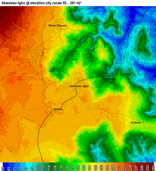
Below is the Elevation map of Akwukwu-Igbo, which displays elevation range with different colors. Scale of the first map is from 55 to 261 m (180 to 856 ft) with average elevation of 163.3 meters (=536 ft) [note 1]
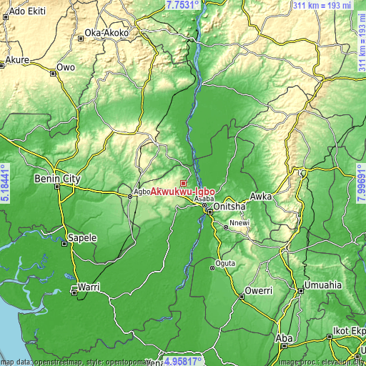
These maps also provides idea of topography and contour of this city, they are displayed at different zoom levels. More info about maps, scale and edge coordinates you can find below images.
| \ | Map #1 | Topo.Map |
| Scale [m] | 55..261 m | × |
| Scale [ft] | 180..856 ft | × |
| Average | 163.3 m = 536 ft | × |
| Width | 9.71 km = 6 mi | 310.8 km = 193.1 mi |
| Height | 9.71 km = 6 mi | 310.8 km = 193.1 mi |
| ↑Max Latitude | 6.401203° | 7.7531° |
| Latitude at center | 6.35753° | 6.35753° |
| ↓Min Latitude | 6.313853° | 4.95817° |
| ← Min Longitude | 6.546715° | 5.18441° |
| Longitude center | 6.59066° | 6.59066° |
| →Max Longitude | 6.634605° | 7.99691° |
Nearby cities:
Cities around Akwukwu-Igbo sort by population:
• Onitsha elevation 57 m
31.6 km,  136°
136°
• Nkpor 124 m
35.1 km,  130°
130°
• Asaba 46 m
23.6 km, 138°
• Ogwashi-Uku 198 m
21.2 km,  200°
200°
• Umunede 247 m
32.7 km,  251°
251°
• Illushi 32 m
35 km,  6°
6°
• Anaku 68 m
39.4 km,  71°
71°
• Ogidi 150 m
37.8 km, 127°
• Nteje 125 m
37.8 km,  105°
105°
• Otuocha 55 m
28.3 km,  94°
94°
• Nzam 27 m
18.6 km,  55°
55°
• Issele-Uku 262 m
13.5 km, 249°
Multilingual:
 En español:
Akwukwu-Igbo elevación 191 m.
 En France:
Akwukwu-Igbo élévation 191 m.
 Auf Deutsch:
Akwukwu-Igbo höhe über dem Meeresspiegel ist 191 m.

Sources and notes:
- [note 1] Map square and city borders are not equal. Map elevation data is calculated only from area inside that square.
- [src 1] Elevation data from geonames database provided with same terms of usage.
- [src 2] The elevation map of Akwukwu-Igbo is generated using elevation data from NASA's 3 arcsec (90m) resolution SRTM data.
- [src 3] Base (background) map © OpenStreetMap contributors tiles are generated by Geofabrik and OpenTopoMap.
Copyright & License:
This Akwukwu-Igbo Elevation Map is licensed under CC BY-SA. You may reuse any part from this page, if you give a proper credit by linking to this URL:
 More info on terms of use page.