Onitsha elevation
Onitsha (Anambra, Onitsha North), Nigeria elevation is 57 meters and Onitsha elevation in feet is 187 ft above sea level [src 1]. Onitsha is a seat of a second-order administrative division (feature code) with elevation that is 240 meters (787 ft) smaller than average city elevation in Nigeria.
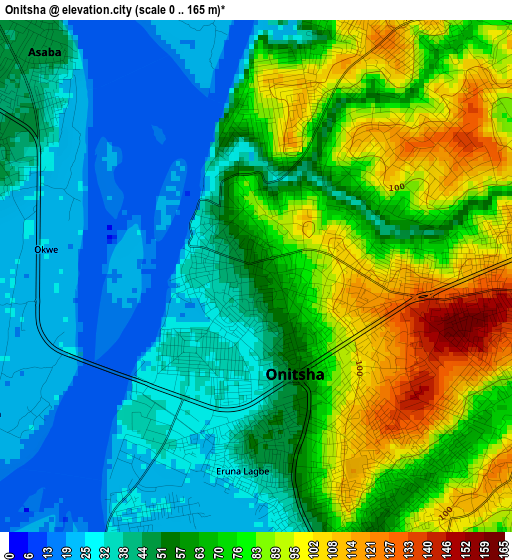
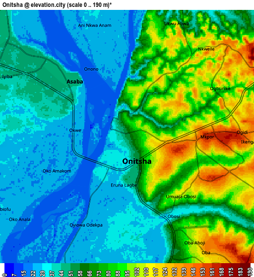
Below is the Elevation map of Onitsha, which displays elevation range with different colors. Scale of the first map is from 0 to 165 m (0 to 541 ft) with average elevation of 58.4 meters (=192 ft) [note 1]
These maps also provides idea of topography and contour of this city, they are displayed at different zoom levels. More info about maps, scale and edge coordinates you can find below images.
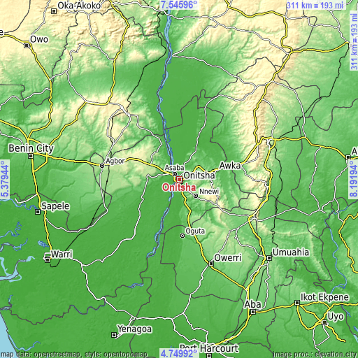
| \ | Map #1 | Map #2 | Topo.Map |
| Scale [m] | 0..165 m | 0..190 m | × |
| Scale [ft] | 0..541 ft | 0..623 ft | × |
| Average | 58.4 m = 192 ft | 59.3 m = 195 ft | × |
| Width | 9.72 km = 6 mi | 19.43 km = 12.1 mi | 310.9 km = 193.2 mi |
| Height | 9.72 km = 6 mi | 19.43 km = 12.1 mi | 310.9 km = 193.2 mi |
| ↑Max Latitude | 6.193471° | 6.237158° | 7.54596° |
| Latitude at center | 6.14978° | 6.14978° | 6.14978° |
| ↓Min Latitude | 6.106086° | 6.062388° | 4.74992° |
| ← Min Longitude | 6.741745° | 6.697799° | 5.37944° |
| Longitude center | 6.78569° | 6.78569° | 6.78569° |
| →Max Longitude | 6.829635° | 6.873581° | 8.19194° |
Nearby cities:
Cities around Onitsha sort by population:
• Atani elevation 25 m
15.8 km,  195°
195°
• Nnewi 151 m
20.5 km,  134°
134°
• Nkpor 124 m
4.9 km,  89°
89°
• Ozubulu 135 m
22.6 km,  160°
160°
• Asaba 46 m
8 km,  312°
312°
• Enugu-Ukwu 220 m
24.4 km,  84°
84°
• Abagana 174 m
23.4 km, 78°
• Otuocha 55 m
22.1 km,  17°
17°
• Ukpo 198 m
21.2 km,  70°
70°
• Nteje 125 m
19.9 km,  48°
48°
• Ojoto 143 m
13.2 km,  140°
140°
• Ogidi 150 m
8.6 km, 88°
Multilingual:
 En español:
Onitsha elevación 57 m.
 En France:
Onitsha élévation 57 m.


Sources and notes:
- [note 1] Map square and city borders are not equal. Map elevation data is calculated only from area inside that square.
- [src 1] Elevation data from geonames database provided with same terms of usage.
- [src 2] The elevation map of Onitsha is generated using elevation data from NASA's 3 arcsec (90m) resolution SRTM data.
- [src 3] Base (background) map © OpenStreetMap contributors tiles are generated by Geofabrik and OpenTopoMap.
Copyright & License:
This Onitsha Elevation Map is licensed under CC BY-SA. You may reuse any part from this page, if you give a proper credit by linking to this URL:
 More info on terms of use page.