Ogwashi-Uku elevation
Ogwashi-Uku (Delta, Aniocha South), Nigeria elevation is 198 meters and Ogwashi-Uku elevation in feet is 650 ft above sea level [src 1]. Ogwashi-Uku is a seat of a second-order administrative division (feature code) with elevation that is 99 meters (325 ft) smaller than average city elevation in Nigeria.
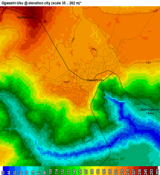
Below is the Elevation map of Ogwashi-Uku, which displays elevation range with different colors. Scale of the first map is from 35 to 262 m (115 to 860 ft) with average elevation of 153.6 meters (=504 ft) [note 1]
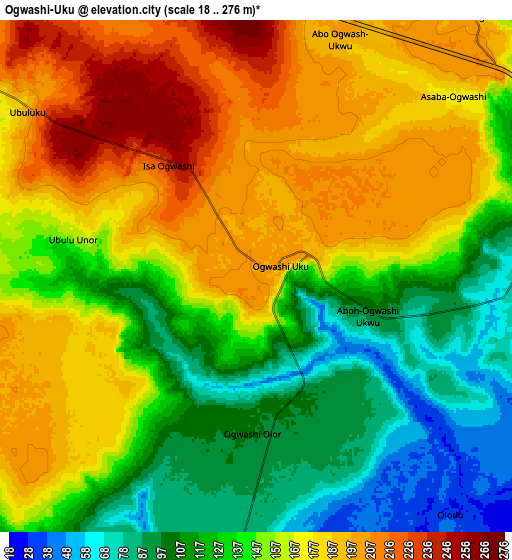
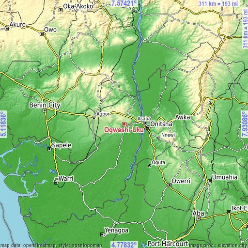
These maps also provides idea of topography and contour of this city, they are displayed at different zoom levels. More info about maps, scale and edge coordinates you can find below images.
| \ | Map #1 | Map #2 | Topo.Map |
| Scale [m] | 35..262 m | 18..276 m | × |
| Scale [ft] | 115..860 ft | 59..906 ft | × |
| Average | 153.6 m = 504 ft | 152.8 m = 501 ft | × |
| Width | 9.72 km = 6 mi | 19.43 km = 12.1 mi | 310.9 km = 193.2 mi |
| Height | 9.72 km = 6 mi | 19.43 km = 12.1 mi | 310.9 km = 193.2 mi |
| ↑Max Latitude | 6.221798° | 6.265483° | 7.57421° |
| Latitude at center | 6.17811° | 6.17811° | 6.17811° |
| ↓Min Latitude | 6.134418° | 6.090723° | 4.77832° |
| ← Min Longitude | 6.480665° | 6.436719° | 5.11836° |
| Longitude center | 6.52461° | 6.52461° | 6.52461° |
| →Max Longitude | 6.568555° | 6.612501° | 7.93086° |
Nearby cities:
Cities around Ogwashi-Uku sort by population:
• Onitsha elevation 57 m
29 km,  96°
96°
• Atani 25 m
30.8 km,  126°
126°
• Nkpor 124 m
33.9 km, 95°
• Asaba 46 m
23 km,  84°
84°
• Agbor 130 m
37.5 km,  282°
282°
• Umunede 247 m
25.7 km,  292°
292°
• Ojoto 143 m
39.5 km,  109°
109°
• Nzam 27 m
38 km,  36°
36°
• Ogidi 150 m
37.6 km,  94°
94°
• Owa-Oyibu 159 m
36 km,  270°
270°
• Akwukwu-Igbo 191 m
21.2 km,  20°
20°
• Issele-Uku 262 m
16.2 km,  340°
340°
Multilingual:
 En español:
Ogwashi-Uku elevación 198 m.
 En France:
Ogwashi-Uku élévation 198 m.
 Auf Deutsch:
Ogwashi-Uku höhe über dem Meeresspiegel ist 198 m.

Sources and notes:
- [note 1] Map square and city borders are not equal. Map elevation data is calculated only from area inside that square.
- [src 1] Elevation data from geonames database provided with same terms of usage.
- [src 2] The elevation map of Ogwashi-Uku is generated using elevation data from NASA's 3 arcsec (90m) resolution SRTM data.
- [src 3] Base (background) map © OpenStreetMap contributors tiles are generated by Geofabrik and OpenTopoMap.
Copyright & License:
This Ogwashi-Uku Elevation Map is licensed under CC BY-SA. You may reuse any part from this page, if you give a proper credit by linking to this URL:
 More info on terms of use page.