Sitalá elevation
Sitalá (Chiapas), Mexico elevation is 1084 meters and Sitalá elevation in feet is 3556 ft above sea level [src 1]. Sitalá is a populated place (feature code) with elevation that is 230 meters (755 ft) smaller than average city elevation in Mexico.
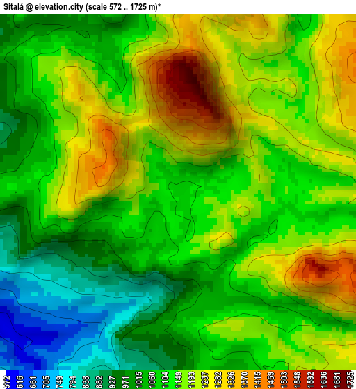
Below is the Elevation map of Sitalá, which displays elevation range with different colors. Scale of the first map is from 572 to 1725 m (1877 to 5659 ft) with average elevation of 1119.6 meters (=3673 ft) [note 1]
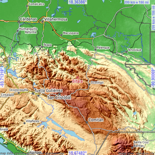
These maps also provides idea of topography and contour of this city, they are displayed at different zoom levels. More info about maps, scale and edge coordinates you can find below images.
| \ | Map #1 | Topo.Map |
| Scale [m] | 572..1725 m | × |
| Scale [ft] | 1877..5659 ft | × |
| Average | 1119.6 m = 3673 ft | × |
| Width | 9.34 km = 5.8 mi | 299 km = 185.8 mi |
| Height | 9.34 km = 5.8 mi | 299 km = 185.8 mi |
| ↑Max Latitude | 17.066185° | 18.36386° |
| Latitude at center | 17.02417° | 17.02417° |
| ↓Min Latitude | 16.982146° | 15.67482° |
| ← Min Longitude | -92.350885° | -93.71319° |
| Longitude center | -92.30694° | -92.30694° |
| →Max Longitude | -92.262995° | -90.90069° |
Nearby cities:
Cities around Sitalá sort by population:
• Yajalón elevation 797 m
16.8 km,  350°
350°
• Chilón 883 m
9.8 km,  21°
21°
• Pantelhó 1203 m
17.6 km,  263°
263°
• San Juan Cancuc 1415 m
16.1 km,  204°
204°
• Bachajón 915 m
12.6 km,  82°
82°
• Tenango 1880 m
13.3 km,  241°
241°
• Tenango 1297 m
14.1 km,  159°
159°
• Guaquitepec 1064 m
5.3 km, 157°
• Tzajalá 1388 m
15.4 km,  323°
323°
• El Pozo 1077 m
16 km,  223°
223°
• San Antonio Bulujib 1047 m
3.2 km, 160°
• Tacuba Nueva 913 m
10 km, 317°
Multilingual:
 En español:
Sitalá elevación 1084 m.
 En France:
Sitalá élévation 1084 m.


Sources and notes:
- [note 1] Map square and city borders are not equal. Map elevation data is calculated only from area inside that square.
- [src 1] Elevation data from geonames database provided with same terms of usage.
- [src 2] The elevation map of Sitalá is generated using elevation data from NASA's 3 arcsec (90m) resolution SRTM data.
- [src 3] Base (background) map © OpenStreetMap contributors tiles are generated by Geofabrik and OpenTopoMap.
Copyright & License:
This Sitalá Elevation Map is licensed under CC BY-SA. You may reuse any part from this page, if you give a proper credit by linking to this URL:
 More info on terms of use page.