Chilón elevation
Chilón (Chiapas), Mexico elevation is 883 meters and Chilón elevation in feet is 2897 ft above sea level [src 1]. Chilón is a seat of a second-order administrative division (feature code) with elevation that is 431 meters (1414 ft) smaller than average city elevation in Mexico.
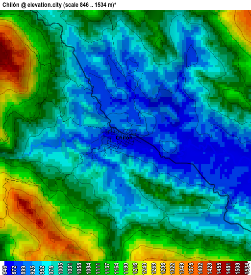
Below is the Elevation map of Chilón, which displays elevation range with different colors. Scale of the first map is from 846 to 1534 m (2776 to 5033 ft) with average elevation of 1039 meters (=3409 ft) [note 1]
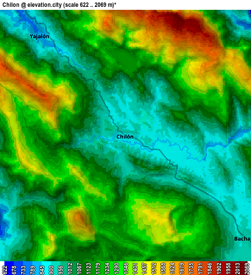
These maps also provides idea of topography and contour of this city, they are displayed at different zoom levels. More info about maps, scale and edge coordinates you can find below images.
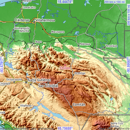
| \ | Map #1 | Map #2 | Topo.Map |
| Scale [m] | 846..1534 m | 622..2069 m | × |
| Scale [ft] | 2776..5033 ft | 2041..6788 ft | × |
| Average | 1039 m = 3409 ft | 1176.2 m = 3859 ft | × |
| Width | 9.34 km = 5.8 mi | 18.68 km = 11.6 mi | 298.9 km = 185.7 mi |
| Height | 9.34 km = 5.8 mi | 18.68 km = 11.6 mi | 298.9 km = 185.7 mi |
| ↑Max Latitude | 17.147657° | 17.189644° | 18.44474° |
| Latitude at center | 17.10566° | 17.10566° | 17.10566° |
| ↓Min Latitude | 17.063654° | 17.021638° | 15.75688° |
| ← Min Longitude | -92.316865° | -92.360811° | -93.67917° |
| Longitude center | -92.27292° | -92.27292° | -92.27292° |
| →Max Longitude | -92.228975° | -92.185029° | -90.86667° |
Nearby cities:
Cities around Chilón sort by population:
• Yajalón elevation 797 m
9.8 km,  319°
319°
• Bachajón 915 m
11.5 km,  129°
129°
• Joshil 1034 m
18.4 km,  328°
328°
• Guaquitepec 1064 m
14 km,  186°
186°
• Tzajalá 1388 m
13.2 km,  284°
284°
• Hidalgo Joshil 666 m
15.7 km, 329°
• Tocob Leglemal 822 m
18.1 km, 321°
• Sitalá 1084 m
9.8 km,  201°
201°
• Amado Nervo 911 m
14.2 km,  11°
11°
• San Antonio Bulujib 1047 m
12.4 km, 191°
• Tacuba Nueva 913 m
10.5 km,  260°
260°
• Lázaro Cárdenas 1006 m
15.4 km,  311°
311°
Multilingual:
 En español:
Chilón, Chión elevación 883 m.
 En France:
Chilón élévation 883 m.


Sources and notes:
- [note 1] Map square and city borders are not equal. Map elevation data is calculated only from area inside that square.
- [src 1] Elevation data from geonames database provided with same terms of usage.
- [src 2] The elevation map of Chilón is generated using elevation data from NASA's 3 arcsec (90m) resolution SRTM data.
- [src 3] Base (background) map © OpenStreetMap contributors tiles are generated by Geofabrik and OpenTopoMap.
Copyright & License:
This Chilón Elevation Map is licensed under CC BY-SA. You may reuse any part from this page, if you give a proper credit by linking to this URL:
 More info on terms of use page.