Bachajón elevation
Bachajón (Chiapas, Chilón), Mexico elevation is 915 meters and Bachajón elevation in feet is 3002 ft above sea level [src 1]. Bachajón is a populated place (feature code) with elevation that is 399 meters (1309 ft) smaller than average city elevation in Mexico.
Below is the Elevation map of Bachajón, which displays elevation range with different colors. Scale of the first map is from 844 to 1637 m (2769 to 5371 ft) with average elevation of 1038.7 meters (=3408 ft) [note 1]
These maps also provides idea of topography and contour of this city, they are displayed at different zoom levels. More info about maps, scale and edge coordinates you can find below images.
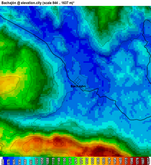
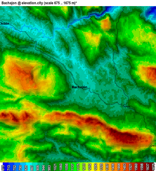
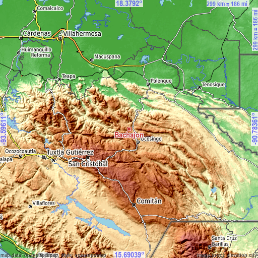
| \ | Map #1 | Map #2 | Topo.Map |
| Scale [m] | 844..1637 m | 675..1675 m | × |
| Scale [ft] | 2769..5371 ft | 2215..5495 ft | × |
| Average | 1038.7 m = 3408 ft | 1089.5 m = 3574 ft | × |
| Width | 9.34 km = 5.8 mi | 18.69 km = 11.6 mi | 299 km = 185.8 mi |
| Height | 9.34 km = 5.8 mi | 18.69 km = 11.6 mi | 299 km = 185.8 mi |
| ↑Max Latitude | 17.081641° | 17.123644° | 18.3792° |
| Latitude at center | 17.03963° | 17.03963° | 17.03963° |
| ↓Min Latitude | 16.997609° | 16.955579° | 15.69039° |
| ← Min Longitude | -92.233805° | -92.277751° | -93.59611° |
| Longitude center | -92.18986° | -92.18986° | -92.18986° |
| →Max Longitude | -92.145915° | -92.101969° | -90.78361° |
Nearby cities:
Cities around Bachajón sort by population:
• Ocosingo elevation 882 m
18 km,  145°
145°
• Chilón 883 m
11.5 km,  309°
309°
• Altamirano 1736 m
17.9 km,  166°
166°
• Tenango 1297 m
16.8 km,  206°
206°
• Guaquitepec 1064 m
12.3 km,  237°
237°
• Sitalá 1084 m
12.6 km,  262°
262°
• Sibacá 1026 m
13.2 km,  156°
156°
• Patria Nueva (San José el Contento) 887 m
14.8 km, 146°
• San Antonio Bulujib 1047 m
12.3 km,  247°
247°
• Tacuba Nueva 913 m
20 km,  286°
286°
• El Mango 621 m
19.4 km,  45°
45°
• Los Pinos 923 m
15.8 km, 146°
Multilingual:
 En español:
Bachajón elevación 915 m.
 En France:
Bachajón élévation 915 m.
 Auf Deutsch:
Bachajón höhe über dem Meeresspiegel ist 915 m.

Sources and notes:
- [note 1] Map square and city borders are not equal. Map elevation data is calculated only from area inside that square.
- [src 1] Elevation data from geonames database provided with same terms of usage.
- [src 2] The elevation map of Bachajón is generated using elevation data from NASA's 3 arcsec (90m) resolution SRTM data.
- [src 3] Base (background) map © OpenStreetMap contributors tiles are generated by Geofabrik and OpenTopoMap.
Copyright & License:
This Bachajón Elevation Map is licensed under CC BY-SA. You may reuse any part from this page, if you give a proper credit by linking to this URL:
 More info on terms of use page.