Tzajalá elevation
Tzajalá (Chiapas, Chilón), Mexico elevation is 1388 meters and Tzajalá elevation in feet is 4554 ft above sea level [src 1]. Tzajalá is a populated place (feature code) with elevation that is 74 meters (243 ft) bigger than average city elevation in Mexico.
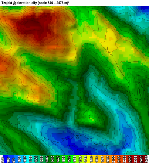
Below is the Elevation map of Tzajalá, which displays elevation range with different colors. Scale of the first map is from 846 to 2476 m (2776 to 8123 ft) with average elevation of 1537.9 meters (=5046 ft) [note 1]
These maps also provides idea of topography and contour of this city, they are displayed at different zoom levels. More info about maps, scale and edge coordinates you can find below images.
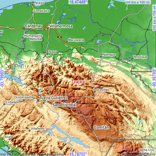
| \ | Map #1 | Topo.Map |
| Scale [m] | 846..2476 m | × |
| Scale [ft] | 2776..8123 ft | × |
| Average | 1537.9 m = 5046 ft | × |
| Width | 9.34 km = 5.8 mi | 298.8 km = 185.7 mi |
| Height | 9.34 km = 5.8 mi | 298.8 km = 185.7 mi |
| ↑Max Latitude | 17.17758° | 18.47445° |
| Latitude at center | 17.13559° | 17.13559° |
| ↓Min Latitude | 17.093591° | 15.78702° |
| ← Min Longitude | -92.437225° | -93.79953° |
| Longitude center | -92.39328° | -92.39328° |
| →Max Longitude | -92.349335° | -90.98703° |
Nearby cities:
Cities around Tzajalá sort by population:
• Yajalón elevation 797 m
7.6 km,  57°
57°
• Chilón 883 m
13.2 km,  104°
104°
• Petalcingo 740 m
10.4 km,  347°
347°
• Chilón 720 m
11.1 km, 347°
• Joshil 1034 m
12.8 km,  14°
14°
• Hidalgo Joshil 666 m
11.3 km,  25°
25°
• Nuevo Sitalá 1423 m
9.5 km,  272°
272°
• Tocob Leglemal 822 m
11 km, 8°
• Aurora Esquipulas 1110 m
9.1 km,  256°
256°
• La Ceiba 586 m
13.3 km, 269°
• Tacuba Nueva 913 m
5.6 km,  154°
154°
• Lázaro Cárdenas 1006 m
7 km, 10°
Multilingual:
 En español:
Tzajalá elevación 1388 m.
 En France:
Tzajalá élévation 1388 m.
 Auf Deutsch:
Tzajalá höhe über dem Meeresspiegel ist 1388 m.

Sources and notes:
- [note 1] Map square and city borders are not equal. Map elevation data is calculated only from area inside that square.
- [src 1] Elevation data from geonames database provided with same terms of usage.
- [src 2] The elevation map of Tzajalá is generated using elevation data from NASA's 3 arcsec (90m) resolution SRTM data.
- [src 3] Base (background) map © OpenStreetMap contributors tiles are generated by Geofabrik and OpenTopoMap.
Copyright & License:
This Tzajalá Elevation Map is licensed under CC BY-SA. You may reuse any part from this page, if you give a proper credit by linking to this URL:
 More info on terms of use page.